Thoughts Become Things

Saturday, July 30, 2016

Flagg Ranch Trail 7/30/2016

Snake River from Flagg Canyon trail
We headed up to the Flagg Ranch area to lose some of the crowds, and because the mountain views further south in the valley were still obscured by smoke. The Flagg Ranch Trail description promised "spectacular views of the Snake River". While we did enjoy the trail, the "spectacular views" were few in number, and only came on the second half of the trip out. See the picture to the left.

Rather than retrace our steps on the Flagg Canyon Trail, we opted to return via the Polecat Creek Trail. The first part of that trail was not promising, as we trudged through dust and dodged horse manure along the way. Horse trail rides come through this way.  But we were rewarded big time for our efforts in the second half of that trail with views down to the creek. We sat just off the trail, ate a late lunch,  and contemplated this view:

I did say that the trail was dusty--so dusty that each footfall created clouds of dust that clung to our skin and clothes. At the end of our 7 mile hike, we took off our hiking shoes to reveal socks and feet that were absolutely caked with dust. Any exposed skin was gritty from the dust which very nicely to our sunscreen.

After dinner, we walked down by Colter Bay once more and found this scene:
Now back to the Rv for a shower. More photos here: https://goo.gl/photos/nHUKbVKi5kQRtNJbA

Tetons 7/30/2016

Because of campsite availability at Colter Bay in the Tetons, we had made reservations there, and worked that around reservations at West Yellowstone (outside Yellowstone) and Fishing Bridge inside Yellowstone. Here's the route--going north to south, then to West then east: https://goo.gl/maps/8x8LUZsqny72 The ride through Yellowstone was... interesting. The road in some places is very narrow as it goes over the mountains, and there is construction in places. At 28 feet plus 15 feet for the car, ours was not the largest vehicle combo by a long shot going over that road. But the ride is beautiful.

We arrived at Colter Bay campground in Grand Teton National Park mid-afternoon. Like most of the others, our site was not the least bit level, and it was a challenge fitting it into the site in a way that would both get it off the road, and be close enough to the utilities (water, electric and sewer) to hook up. The RV has to be level for the refrigerator to work properly. That challenge met, we chilled out for the rest of the day, and in the evening took a walk down by Jackson Lake where we saw a bald eagle perched in a tree. 

__________

Smoke obscures the Tetons
Yesterday we drove down to the Laurence D. Rockefeller Preserve, a former ranch donated to the park service (along with thousands of other acres that form Grand Teton National Park). The mountain scenery that greeted us was veiled in smoke and the smell of smoke was in the air. There are substantial fires south and southeast of here. 

At the Preserve, we took a loop trail that took us by lovely Phelps Lake. The Preserve has a wonderful and unusual visitor center. While most visitor centers give you lots of historical, ecological and geological info, all this center tries to do is to get you in a frame of mind to experience the beauty of the preserve itself. There is little reading, but lots to engage your senses. The first room you enter has high definition nature videos. Later you encounter a soundscape room with nature recordings from the Preserve. All you are asked to do is look and listen. There is a reading room as well, filled with books about the area and nature, and fitted with comfortable chairs in a room with views to the mountains. Gorgeous.

Outside view of  Episcopal Chapel

View behind the altar of Episcopal chapel
On our drive back we stopped at the Church of the Transfiguration, an historic Episcopal chapel  with a view behind the altar to the Teton peaks, and the Chapel of the Sacred Heart, a Catholic Chapel with the same designation. As you can see from the pictures--pretty inspiring, huh?


Thursday, July 28, 2016

Two Medicine 7/28/2016

The view from the edge of the lake at Two Medicine
The day after our visit to Iceberg Lake, we headed down to the southern parcel of Glacier at Two Medicine. Because it is a bit more distant, and not connected to the Going to the Sun road, fewer people typically visit this area. That makes it more attractive as far as we're concerned. The drive out to Two Medicine was, as usual, gorgeous. On the way, we stopped to note that the forest that had burned many years ago was now covered with new growth of trees--nature renewing itself.
New trees growing after fire


The hike we chose at Two Medicine was a short one (4 miles round trip), and the elevation gain was minimal compared to many others in the park, about 650 feet. What we found out was that all the elevation gain was at the last 1/2 mile, making that portion pretty steep. I must say I sweated my way through that last half mile. On the return, dark clouds were gathering, and we could hear rumbling thunder. But we witnessed just a few sprinkles.
We saw a moose off the trail in the water. After our hike, we drove over to the East Glacier hotel,  where the road in to the hotel was covered with gravel, a result of the storm that we had missed. Apparently the downpour there was heavy, and there were large puddles everywhere. On our return to St. Mary, we saw a few piles of accumulated hail along the side of the road. Such is the hit and miss nature of weather in the mountains, I guess.

One thing we have dealt with on this trip that we never had to before is bugs. In Michigan and Minnesota, I managed to pick up at least 15-20 mosquito bites on my legs. Here at Glacier, the hike to Iceberg was plagued by flies and bees. At Two Medicine, I was bitten several times (5-6) right through my compression sleeve (I think those bites might be from deer flies.), and got several more on my legs.  Oddly, Ray has no bites. He's usually the one to get bitten.
_________

Wheat and canola fields
Yesterday was a travel day--going from St. Mary area of Glacier down to Livingston, where we would stay one night before heading to Colter Bay at Grand Teton National Park.  We took the less traveled route down Route 89 rather than the Interstate, and enjoyed the ride. We traveled through lots of farmland, and loved the visual contrast between the wheat fields (tan colored--amber waves of
grain!) and the canola fields (bright yellow). Our campground is on the Yellowstone River about 50 miles north of Yellowstone National Park. We woke this morning to the bellowing of moose nearby (https://www.youtube.com/watch?v=--PyKhohVcY).

Tuesday, July 26, 2016

Iceberg Lake 7/26/2016

We had never visited Glacier NP at this particular point in the summer season. Our forays here were always in the very beginning of July. One time here, we arrived a day after the Going to the Sun Road was opened. As a result, our hikes to Iceberg Lake (actually 10 miles roundtrip, we discovered) were always taken at the height of wildflower bloom time for the lower part of the hike.

So when we started out on the trail, we were somewhat surprised to see that while there were some wildflowers, there were not the eye-popping drifts of flowers we had witnessed previously. But, of course, the mountains never disappoint, and the views from the trail were, as ever, spectacular. What
Meadow near the lake. Photos can't capture how stunning it was.

we found out, though, was that the second half of the trail (past Ptarmigan Falls) which was never, for us, a wildflower standout, was, at this point in the season, crazy with flowers. As a matter of fact, the last part of the trail approaching Iceberg Lake had in past years been covered with snow. I have pictures of us walking on snow so deep we could touch the treetops. Not this year. Reds and yellows interspersed with drifts of white and purple were everywhere in the meadows in this part of the trail. This trail never disappoints.

When we got back to the RV, later in the afternoon, we relaxed for a bit with a beer or 2, then decided to treat ourselves to dinner at Johnson's restaurant. We brought back to the RV some Huckleberry Ice Cream pie for dessert--a satisfying end to a great day.

Iceberg Lake as you approach from the trail. Usually there is a much larger iceberg in the lake that persists. This year it was VERY small. 


Sunday, July 24, 2016

Beauty from fire 7/24/2016


In 2015 there were 2 major fires in Glacier National Park. One was the Thompson fire that consumed almost 19,000 acres west of the Two Medicine area of the park. The other was the Reynolds Creek fire which burned 4800 acres. The one that headlined the news was the Reynolds Creek fire because the flames reached the Going to the Sun road, and burned along the shore of St. Mary Lake. The Going to the Sun road was closed for a time last summer.

What we found in the wake of the fire, was a glorious experience. Our trail today was from Sundrift Gorge to Baring Falls to St. Mary Falls to Virginia Falls, about an easy 6 mile round trip. The view from the road is ominous: blackened trees everywhere. But as soon as you step on the trail, you can see that nature has already started to rebuild the area. Where the tree canopy was gone, and sunlight , could now penetrate, wildflowers were everywhere. Purple, pink, yellow, red, and white--in all shades. With the tree foliage gone, the lovely St. Mary Lake was visible--a shining, wind whipped green gem.

The waterfalls along the way were lovely, but for me the real attractions were the wildflowers drifted everywhere, and the spectacular lake forming a backdrop.

Having finished this hike, we headed up to the Logan Pass area (located on the Continental Divide at the highest point in Glacier NP) and decided to take the  3 mile round trip Hidden Lake overlook trail. Halfway through, my knee told me it was time to rest. Ray continued to the overlook, and I turned back.


Friday, July 22, 2016

Highline 7/22/2016

Gorgeous multi-colored wildflowers lined the trail

Note the mountain goat above the trail, and the hand-hold along the rocks
This morning we decided to try to clean the thousands of crusted bugs off the front of the RV.  Bugs from Michigan and Minnesota especially plastered themselves for their last ride on the front of the Winnebago. A neighboring camper suggested LA's Awesome cleaner from the Dollar Tree. We didn't have the soap cleaner, but did have the orange one. It worked great: spray, let it sit, wipe the bugs off:
one of the less glamorous aspects of Rving.

With that done, we headed for  the site of today's hike: Logan Pass, in the middle of Glacier National Park. We arrived via the Going to the Sun Road. If you have never driven it, we highly recommend putting it on your bucket list. The word "spectacular" does not do it justice. The Highline Trail runs
along a ridge for 11 miles, and delivers incredible views all along the way. It is a
Across the stream
relatively easy walk, although for those averse to heights, there are a few places where the trail runs close to the edge of the steep mountain. For the most part, the views are breathtaking. We did encounter mountain goats and a friendly marmot on the trail. On the way back, thunder rumbled and it started to rain. As the wind picked up, the rain turned to something like sleet, but thanks to a wind at our backs, only our backs (and heads) got wet. Nevertheless, this was an unbelievably beautiful trail, and we'll be back.

Mountains and a mountain of laundry 7/22/2016

We arrived yesterday at the West Glacier KOA after a windy (as in blowing wind) drive. Nothing like driving 2 lane roads with construction with a gusty wind blowing. Mileage that normally tops out at 7.5 mpg may be even less the next time we fill up. Just for the record, a fill up is usually 50-60 gallons. You do the math. Nevertheless, we're loving the experience.

Our campground is pretty much top of the line as campgrounds go. The roads are gravel, not dirt. The campsites are separated by green grass and bushes, and the facilities are all impeccable. The only thing lacking is wifi. That's available in one spot on the campground from which I am writing this. I could use my data, but my billing month just started, and we have at least 3 1/2 weeks at least til we get home, so we're trying to be judicious about using data.

After we arrived here, task #1 was to get laundry done. Laundry is one of those unfortunate realities that must be attended to. So we hung around the campground laundromat waiting for our stuff to get done.

__________

Today we set out with the goal of taking at least 2 hikes: one at Rocky Point near the Fish Creek Campground, and the other at Avalanche, and area a little further east. The Rocky Point trail took us be an area that had been burned in 2003, and it still bore evidence of that. There were a few nice views of Lake McDonald along the way. It was an easy 2 mile walk.

We headed over to the Lake McDonald Lodge, and had lunch at a picnic table there (you know what we had, right, Alex?) From there, we started over to Avalanche. That trail starts out along Avalanche Creek, and takes you up a steep climb along a gorge cut by the creek. The waterfalls and rushing water in the gorge are stunning. At about 1 mile in, the trail veers away from the creek and turns inland. Along this stretch of the trail, you can see hundreds (thousands?) of downed trees, the result of  recent Avalanches on Mount Cannon. At the end of the trail (2.3 miles) sits Avalanche lake, a green gem rimmed by mountains with cascading waterfalls. Blue sky, the mountains, the green lake, a gorgeous day--perfection.

We lingered a while at the lake, then turned back for a leisurely return.

Wednesday, July 20, 2016

Travel day through ND to MT 7/20/2016

Montana Route 200
Our next door neighbors in the campground were occupying an Adventurer similar to the one we just traded in, and were curious about our newer coach. Ours is unusual because it is a smaller class A (meaning bus configuration), and has multiple slides. Most buses are considerably larger. We met and spoke with this lovely couple and discovered that they were from Connecticut (she, from England originally), and, like us, had just purchased the Adventurer to try out motorhome travel. After the 25 cent tour of our home on wheels, we traded stories about our travel, then said our goodbyes.

The trip to Great Falls, MT was mostly uneventful, with scenery views stretching to the horizon, especially once we left the interstate and set out on Montana Route 200S, a long, straight ribbon of a road that spans the eastern 2/3 of the state. It's a 2-lane road that is only very occasionally punctuated by towns. We did pass a few places where there was serious construction, and had to wait for the flag person to guide us down the road. Elsewhere, we saw pronghorn in the fields, an occasional lonely house, cowboys rounding up cattle, wheat and corn fields, and lots of sky.

Once we arrived at our campground in Great Falls, we had dinner and went for an evening stroll on the campground's nature trail. This path provided expansive views of the mountains beyond the city, the wheat fields and the setting sun illuminated the wildflower-filled meadows around us. Beautiful.

Tuesday, July 19, 2016

North Dakota 7/19/2016

Farmland is the major feature of North Dakota, and we saw plenty of it as we rolled down I-94. Not surprisingly, it was windy--again. Our first event of the day came early when 2 birds chased each other from the side of the road into our windshield and grill. We both watched them fly up and cringed at the subsequent thuds we saw and heard. Yuk.

Onward. We started to note a change in the countryside from flat to the horizon to a hillier profile. Shortly after the change, we saw a sign  for the Painted Canyon Overlook, the intro to North Dakota's badlands located off I-94. At this stop we struck up a conversation with an older gentleman who we learned was from Minnesota, currently living in Bend, OR. He had run a distribution business in MN. These chance encounters are one of the great bonuses of travel.

Leaving the Painted Canyon, we headed for Medora in western ND, our stop for the day. Once the RV was set up, we set out for Theodore Roosevelt National Park south unit, whose entrance was just down the road from the RV park where we were staying. There is an auto road on which you can make stops and take short hikes to scenic spots, and that was our plan. One of these stops was at Wind Canyon, where the path takes you up along a river with views of the canyon below. While the
On one of the trails
trail is named for the canyon, the highlight for me was at the highest point on the trail that overlooked the river valley. At this point, in the distance, we watched as a group of bison lingered in the shallow river, as others moved into the field beyond. As we stood there, with the birds singing, and the wind blowing in trees, it was hard to not to imagine that perhaps Lewis and Clark might have stopped in this very place over 200 years ago and observed the scene with the same wonder and peace we felt.

Sunday, July 17, 2016

Duluth: Pokemon Go City 7/17/2016

Everyone in this photo was playing Pokemon Go
After arriving in the Duluth area following our marathon drive to get here, we had a cold, rainy day. We replenished groceries and decided to just hang out for a day.

Yesterday we drove into Duluth to check out the Lakewalk, a 4.2 mile path built by the city of Duluth that runs, for the most part directly along the shore of Lake Superior. We discovered that the Lakewalk was built in response to planners who had wanted to extend I-35 500 feet out into Lake Superior. The people of the city revolted against that plan, and the result was that the I-35 corridor was buried under the city, and the lakefront developed into a beautiful park. In the park, there is both a paved path for rollerbladers, bicyclists, runners and wheelchairs, and a boardwalk for pedestrians. This scenic path passes the Duluth aerial Lift Bridge which spans the Duluth shipping canal and is raised and lowered to let ships pass. The trail also passes the Canal Park entertainment district, and sculptures representing Duluth and its sister cities in Sweden, Russia and Japan, the Northland Vietnam Veterans and Korean War Memorials, Leif Erickson Park and the gorgeous Rose Garden with 3000 rose bushes of some 99 varieties and numerous trees, shrubs and other flowers. It's hard to believe that as you stroll through the garden, you are walking over cars and trucks streaming along I-35.

The storm that brought 10 inches of rain to the area a few days ago  (and caused our crazy detour), swelled rivers and streams to overflowing, and churned up silt along the way. As a result, the
The normally clear blue Lake Superior after the storm
normally clear, blue Lake Superior was sporting a lovely shade of brown from the runoff from these sources as well as from erosion from red clay cliffs in the area. It was really amazing to see a brown Lake Superior, when a few days earlier at Munising, MI, the Lake was very clear and sparkling blue.

In Leif Erickson Park we stopped for lunch and did a bit of people-watching. I noted that almost every person in the park was deeply engrossed in their cell phone. It was a beautiful day, and even people in groups were not talking to each other as they strolled, but instead were focused on their phone screens. Others were just standing around staring at their phones. Curious, I approached one group of young men and inquired about the phenomenon, and discovered that everyone was playing Pokemon Go. As we continued our walk, we started noticing the large numbers of people engaged in the game, and had a few near-collisions with people who were walking-while-playing and not watching where they were going. Mass hysteria!
Here are a few others photos of the day: https://goo.gl/photos/eejFPzuG2iRAVA4k7


Wednesday, July 13, 2016

Our Magical Mystery Tour 7/13/2016

We departed Newberry under clear skies and warm temps. The 6 hour drive ahead to our destination near Duluth, MN looked like a piece of cake. The drive across the UP (Upper Peninsula of Michigan) promised to be free of heavy traffic, and fairly level, with clear skies above us and warm temps. Oh, but reality did not meet expectations. Our first challenge: strong winds. As we set out on M-28 West, the road west across UP, winds were averaging 20 mph, gusting to 40 mph. Maneuvering a 10 1/2 ton rig on a two lane road through that type of wind is not exactly a party.

Tuning in to local radio proved to be an experience: One station offered a contest whose prize was a stay-cation in a local town in a furnished cottage, complete with a pontoon boat. The contest was sponsored by a company that sells back-up generators. I guess I won't be entering that contest.

The UP is so rural that you could pick most any place and drive 50 miles in any direction and find yourself in the middle of a Great Lake or the forest.  The bigger towns here are Ishpeming, Marquette, Manistique, and Escanaba. Never heard of them? No surprise. The town of Kenton is home to the world-famous bar: Up-Chuck's (no joke).

So what of our crazy drive? At Wakefield, where M-28 ends and Route 2 begins, we started to see significant damage from the storm that passed though here a few days ago. 10 inches of rain was dumped on this area, accompanied by strong winds. Trees were uprooted, and snapped at their bases, and major roads flooded. Including Route 2 just west of Ironwood, the town on the western border of Michigan with Wisconsin, our intended route. So we did what any reasonable traveler would do, we
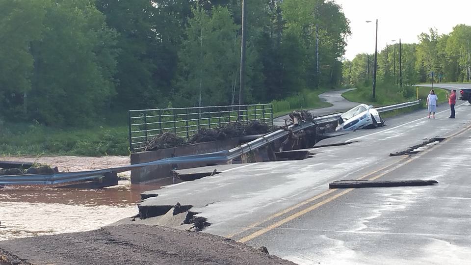
Route 2
took the detour offered by the state DPW, and followed the signs, a move which set us on the detour from hell. It turned out that not only the main road we needed to take was flooded, but other roads
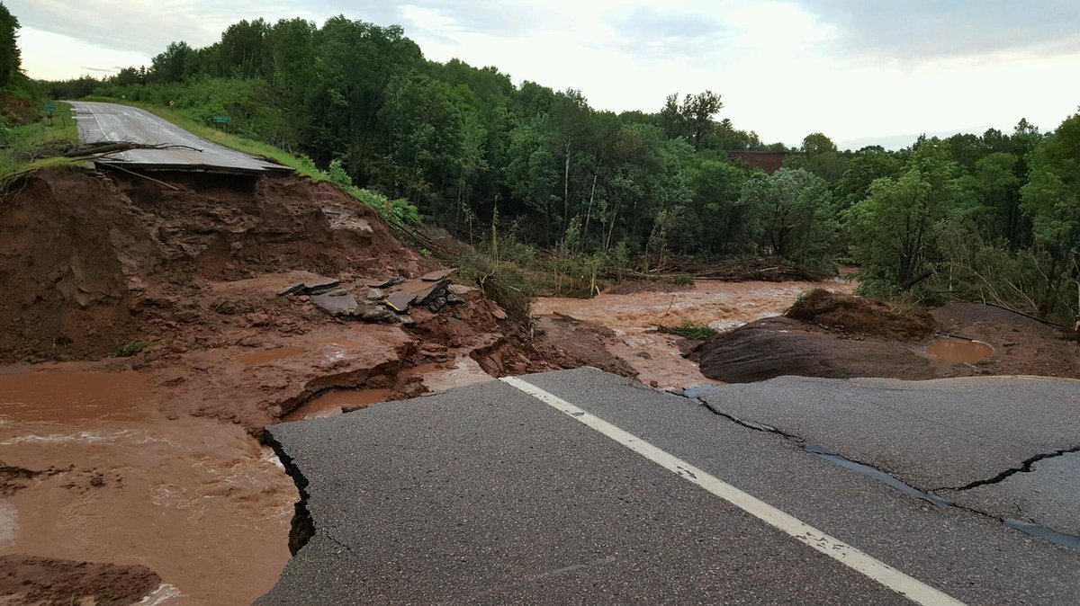
One of the other roads we could have taken to get us on our way sooner.
that might have given us better access to be on our way were flooded as well. The detour took us about 1 1/2 to 2 hours out of our way, through Wisconsin hinterlands, up and down hills and through small towns. We went through one town where the water on Main Street was still at least a foot high, but that was the only access available. Police were there watching as vehicles forded the street. So we plowed through as well. That was in Round Lake, WI. One highway we took was closed on one lane due to ponding water still on the road.

Once we got back on the main road to our destination, it started to pour. We noted as we went over the bridge into Duluth that the bay at the entrance to Lake Superior was brown, like many of the swollen rivers we had seen on our drive, in contrast to the clear blue of Lake Superior.

We arrived at 6:00 local time (accounting for the change to Central time, and after about 9 hours on the road), ready for a glass (or 2) of wine.


Tuesday, July 12, 2016

From the Water 7/12/2016

The advice on Trip Advisor was right: if you come to Pictured Rocks, you haven't really seen the place without taking the cruise on Lake Superior to see them from the water. We took the early afternoon 2 1/2 hour cruise, and while it started out a bit cloudy, the weather cleared and warmed up nicely. What you can see fro a land point of view is Lake Superior and the dunes. What you can see from the water is the glory of Pictured Rocks, 40 miles of sandstone cliffs that sit 200 feet above Lake Superior. The blues, greens, yellows, oranges and reds in the rocks are created when the water seeping through and over the rocks leeches the minerals out. It is absolutely beautiful, and the effect is like that of a painting--hence the park name. See for yourself:


Monday, July 11, 2016

Pictured Rocks 7/11/2016

We are staying in Newberry, MI, on the Upper Michigan Peninsula, about as far north as you can get without being in Canada. Yesterday we left Mackinaw City, and traversed the Mackinac Bridge, a technological marvel in itself. It is the 5th longest suspension bridge in the world, and the longest in the western hemisphere. The total length of the bridge is 5 miles, and the suspension part is 1 5/8 miles.
On the bridge

The bridge connects the lower Michigan peninsula with the Upper Peninsula, our destination. Since our campground was only 1 1/2 hours away, we arrived, set up and took off to check out Whitefish Point, the location of Whitefish Point Light, the oldest operating light on Lake Superior. All vessels entering and leaving Lake Superior must pass the light. It stands on the treacherous southern shoreline of Lake Superior known as the "Graveyard of the Great Lakes" in an area with more shipwrecks than any other area of the lake. Our visit to the Point was a leisurely one, as we took time to walk the beach, take a short trail, and sit and check out the interesting rocks on the beach. I thought it very cool that when dry, the rocks looked unassuming, but when wet showed beautiful colors and patterns. I selected a few to bring home, and Ray kept comparing me to Lucy in the movie "The Long, Long Trailer". If you love Lucy, watch this--it's a hoot. Here's a map of where we went.

It's amazing how few people live up here. Newberry itself is a metropolis in these parts, with a population of not quite 1500 people. Mostly what you see when you drive these roads is trees. Every so often, you might see a small home set back off the road, but the trees rule here. And the lake. Superior is so big, it comprises 10% of the world's fresh water. Superior is the cleanest and clearest of the Great Lakes. Thanks to low amounts of nutrients, sediments, and organic material, you can see about eight feet under the water. The edges of the lake remind me of the Caribbean, green and clear. Standing on a beach, it truly looks like an ocean. 
_____

Today we set off the explore the Pictured Rocks National Lakeshore, a natural area that hugs the Lake Superior southern coast for more than 40 miles. The park offers spectacular scenery of the hilly shoreline between Munising, Michigan and Grand Marais, Michigan, with various rock formations
Castle Rock
like natural archways, waterfalls, and sand dunes. The park gets its name from the 15 miles of colorful sandstone cliffs northeast of Munising. Today we took many of the short hikes
to important locations in the park: a couple of the lovely waterfalls, and a place where loggers used to offload their logs and slide them down a huge
Log slide dunes
dune into Lake Superior. We did walk the beach, and experienced the blight of stable flies common in these parts. We were not heartened by the information that bug spray does not deter them, and that the only way to keep from being bitten is to cover up. 

We have been told that the best way to view the colorful beauty of Pictured Rocks is by boat, so tomorrow we will be taking a cruise along the coast to check that out.


Sunday, July 10, 2016

Mackinac Island 7/10/2016

Woke up this morning to the squawking of a seagull on our roof. Who needs a rooster when you have a seagull? No one had camped next to us, so we had a clear view of Lake Huron, which was whipped up by the wind, and looked a lot more like the ocean. Today we headed to Mackinac Island.

The French Pronounced it "aw" but spelled it "ac". The British heard it pronounced "aw" so they spelled it that way. Whichever way it is spelled, it is always pronounced "aw".  So that's why Mackinac is pronounced "Mackinaw." Mackinac Island is an island and resort area located in Lake Huron between the Upper and Lower Michigan peninsulas. In the late 19th century, the island became a popular tourist attraction, and much of it has since undergone extensive historical preservation and restoration, and it is listed on the National Register of Historic Places.

Other than that info about the place itself, there are a few other things we learned during our visit there yesterday. There are 2 ways to get to the island and the most popular method is by ferry. Automobiles are not (for the most part) allowed on the island, so ferries take people and bikes only. Transportation around the island is by 2 methods also: bike and horse. which brings me to our first impression of Mackinac Island--OMG, the smell.
Typical of most streets. They have people coming around to clean up , but it's impossible to keep up.

Stepping off the ferry, we were immediately greeted by strong breezes carrying the unmistakable aroma of horse manure and urine. My first thought was NOT "How authentic! How charming!" Horses are everywhere. Horse carriages are for rent everywhere. Horse manure is everywhere. As a result, the smell of manure and urine (especially in town) is overpowering. The gutters by the sidewalk are frequently filled with brownish fluid--and it wasn't raining...

The main streets of the island are lined with tourist shops selling everything any tourist might want: T shirts, candy (fudge is a big thing here), jewelry, clothing, and food. Ergo, there were throngs of people on the sidewalks, and lots of people on bikes--the other bane of this place. Normally, bikes wouldn't be so bad. But when you consider that 3/4 of these people haven't ridden a bike in 10 years, and then put them all together in a place with all kinds of distractions... Nothing like dodging bicyclists who are tooling down the street unaware of what's in front of them because they're interested in that candy shop they're passing. Kids on bikes are another issue. The young ones can be unsteady, and the older ones too sure of themselves as they zoom down the street--don't forget to swerve to avoid the horse poop! Crossing the street on foot is an adventure as you are approached from the rear by a bicyclist who doesn't warn you of his approach. At least you can hear the horses coming.

Our first order of business was to trek over to the Grand Hotel, a Victorian behemoth that sits atop a bluff overlooking the lake. We were advised by the island welcome center staff that to gain admittance to the porch to observe the view would cost us each a cool $10.00. We decided to skip that and hike up to another bluff for a free view.

One of the island's "cottages"
Once you get out of town, the island is lovely. Via paths in the woods, we walked over to Arch Rock, a natural limestone arch. The architecture around the island is very much Victorian, with many grand "cottages" sitting on the bluffs overlooking the lake. 80% of the island is a state park and when the state park was established, the state leased the land for people to build cottages. The cottages were later sold to the wealthy who developed them as grand mansions.

The weather was fantastic during our day here--high 70s and dry. We spent a bit of time lying on the grass in the park under the shade of some gorgeous elm trees. We're glad we came to visit this unique corner of America.

Friday, July 8, 2016

Mackinaw City 7/8/2016


After a short drive (5 hours) from Dearborn, we arrived at our next stopping place, Mackinaw City, MI. Mackinaw City sits at the tip of the Lower Michigan Peninsula, at the place where Lake Huron meets Lake Michigan. The Straits of Mackinac (pronounced Mackinaw), connect those two Great Lakes. Mackinaw City is the northernmost city on the Lower Peninsula.

On the way, we passed lots of flat farmland, punctuated by Sea Shell City in Cheboygan, home of the Man Killing Giant Clam. What A country!

Our campground sits directly on Lake Huron, with great views of the 5 mile long Mackinac Bridge that connects Mackinaw City with St. Ignace on the Upper Peninsula (U.P.). Yesterday, we arrived, set up, walked the campgound, then had a glass of wine (or 2) and dinner. Soooooooo stressful.

Today we woke to thunder and weather predictions for nasty thunderstorms, heavy rain, lightning and potentially damaging hail (there was hail 3" in diameter just south of here). We opted to take the opportunity to go into Cheboygan to do laundry. While thunder, lightning, and pouring rain greeted us on our return, it subsided within an hour, and we then set out to check out Mackinaw City. Mackinaw City is a tourist's heaven: shoppes (as distinguished from shops) galore, restaurants, and hotels-motels, like a thousand other tourist places on the water.

The bridge itself is quite the construction marvel. It is 5 miles long, the longest suspension bridge with two towers between anchorages in the western hemisphere.

Later in the afternoon, as the weather improved somewhat, we drove over to the McGulpin lighthouse, completed in 1869, as a lighthouse on the Straits of Mackinac, and walked down to Lake Huron from the lighthouse. Interesting history.

Since the weather will be improving tomorrow, we will head to Mackinac Island which sits in Lake Huron at the eastern end of the Straits of Mackinac between the Upper and Lower Michigan Peninsulas.

Thursday, July 7, 2016

The Henry Ford Museum 7/7/2016

The chair Lincoln was sitting in when he was shot at Ford's Theater
What can everyday objects created by ordinary people tell us about new ways to solve problems and make life better? A great deal, Henry Ford believed. To show it, he amassed a vast collection of artifacts documenting the genius of the American people—and then created a nine-acre showcase in Dearborn, Michigan in which to share it. Today, this museum is a remarkable place that shows us the breakthroughs, big and small, that have made our world what it is today.

This museum has it all: George Washington's camp cot, one of the first McDonald's signs, a HUGE Allegheny locomotive (the most powerful steam locomotive ever built), and a Dewitt Clinton locomotive (looks like a locomotive pulling a bunch of stagecoach bodies) from the early 1830s, a fabulous collection of autos, including the Kennedy assassination limo, agricultural equipment spanning centuries, a display with actual models of power plants throughout the ages, the only surviving Buckminster Fuller Dymaxion house,  and SO much more. I loved this page from the White Castle employee handbook:

Probably my favorite item is a vial of Edison's last breath. If you're ever in this part of the country, go out of your way to visit!

Tuesday, July 5, 2016

Greenfield Village 7/5/2016

Another picture-perfect day greeted us as we departed the grey house yesterday. We rolled through the hills of NY and PA, through the home of Lucille Ball (Jamestown, NY, home of the Lucy and Desi memorial bridge and also to the Lucy Desi Center for Comedy), and through the farmlands of the midwest to our stopping place for 3 nights in Ypsilanti, MI.

Today we visited Greenfield Village, an 80-acre outdoor museum consisting of various historic buildings Henry Ford assembled from around the USA. At the museum, there are 83 authentic historic structures (disassembled at their original places and reassembled at Greenfield) , from the lab where Thomas Edison developed the lightbulb to the workshop where the Wright Brothers
developed their airplane, and the building where Abraham Lincoln practiced law. You can visit the home where Noah Webster wrote the first American dictionary and the farmhouse where Henry Ford grew up. To keep things authentic, Ford transported Thomas Edison's Menlo Park, NJ lab to Dearborn, along with 6 railroad cars full of NJ soil so the lab could sit on NJ soil. Throughout the village are actors and interpreters who bring the history of those places to life. According to Henry Ford, "We ought to know more about the families who founded this nation, and how they lived. One way to do that is to reconstruct as nearly as possible the conditions under which they lived." He did that wonderfully at Greenfield Village.


Monday, July 4, 2016

Grayson 7/4/2016

Thanks to the hospitality of Granny Cartwright and the hard work of others to prepare the grey house for our visit, we enjoyed 3 nights there within a short drive of all the festivities for Grayson's christening. My brother, Steve (Father Steve to others) joined us there.

The christening was perfect, and Grayson himself seemed to enjoy is as he smiled broadly as Steve poured the christening water on his forehead.

We capped off the ceremony with a wonderful family gathering at Jenna's mom's home a short distance from the church. The weather was perfect (mid 80s, dry and sunny), the food was great (chicken barbecue and all the fixings), and Grayson smiled or slept through it all.

We were so happy that our niece, Barbara (born 1 month after Alex), came for the christening with her sons Pierce (3 years old) and Elvis (born just 2 weeks after Grayson).
Grayson and Elvis
It was great that another cousin, Kristen, also took the long drive up with her family (husband Mario and 2 children Marion and Giuliana) to celebrate with us.

Sunday we were invited to attend a Cartwright family Independence day celebration at Silver Lake in the town of Perry, NY. The party was hosted by a Cartwright cousin, Terry, and his wife Joan, whose gorgeous home sits directly on the lake. We watched as the sun set, and then were treated to an amazing fireworks display personally arranged and coordinated by Terry. It was the perfect cap to a lovely weekend. Sweet Grayson, feeling all the love around, slept through it all.