Thoughts Become Things

Tuesday, July 31, 2018

Roaming Kansas dirt roads 7/31/2018

We had read that just south of where we are staying there are a few unusual scenic places: Cedar Bluff State Park, Threshing Machine Canyon,  and the Castle Rock Badlands. The latter 2 were on a list of 8 Kansas Wonders. That sounded good to us!

Following Google directions, we headed south in the Elantra, away from the Interstate. A 2-lane 65 mph road led due south like an arrow shooting through  Kansas farmland. We passed a picturesque church, the only building on the road, and shortly realized that we should have turned at the church to head to the Badlands. This was route 458, otherwise known as local R road, known elsewhere as an
S Road (I think)
"unimproved road". We did hope that it would eventually change to pavement. No such luck. After 20 miles of right and left turns, passing at least 4 snakes (2 of them very large) crossing the road, many washboard areas, acres and acres of corn and sorghum, no houses or buildings, people or cars, a few pieces of farm equipment, and some cattle, we made the turn for Castle Rock. As we approached the area, Google directed us to take a right turn. Ahh, no. I guess there 
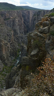
used to be a road there. A rocky, cavernous, axle-destroying path is what was left. So we figured we would take the other road (loosely describing the other fork) as far as we could go--which turned out to be about 50-75 yards.  That road was so badly rutted that we didn't dare try advancing through it. It would take AAA more than a couple of hours to get to us there. So we just stopped, and started to explore the rock formations that were within walking distance. It was a beautiful area, with views across the landscape, carpeted with wildflowers, with not a soul around. All we could hear was the buzz of cicadas.  I joked to Ray that if we met our demise here, our bodies would never be found. It looked like we may have been the only visitors here in quite a while.

After the Castle Rock Badlands, next on the agenda was Cedar Bluff State Park. Again, dirt roads, farms, corn, sorghum, no houses or people, etc, etc. We arrived and went to the park office to be directed to Threshing Machine Canyon, which was supposedly nearby. The Kansas tourism office had instructed us to inquire there for directions. The young girl at the desk (the only person there) had never heard of it. Threshing Machine Canyon is the site of an 1850s Native American attack on a wagon train bearing a threshing machine, where there are carvings in the rocks dating back to the mid-1800s. At any rate, with no one else to ask, we tries to figure out where it was. We found a trail
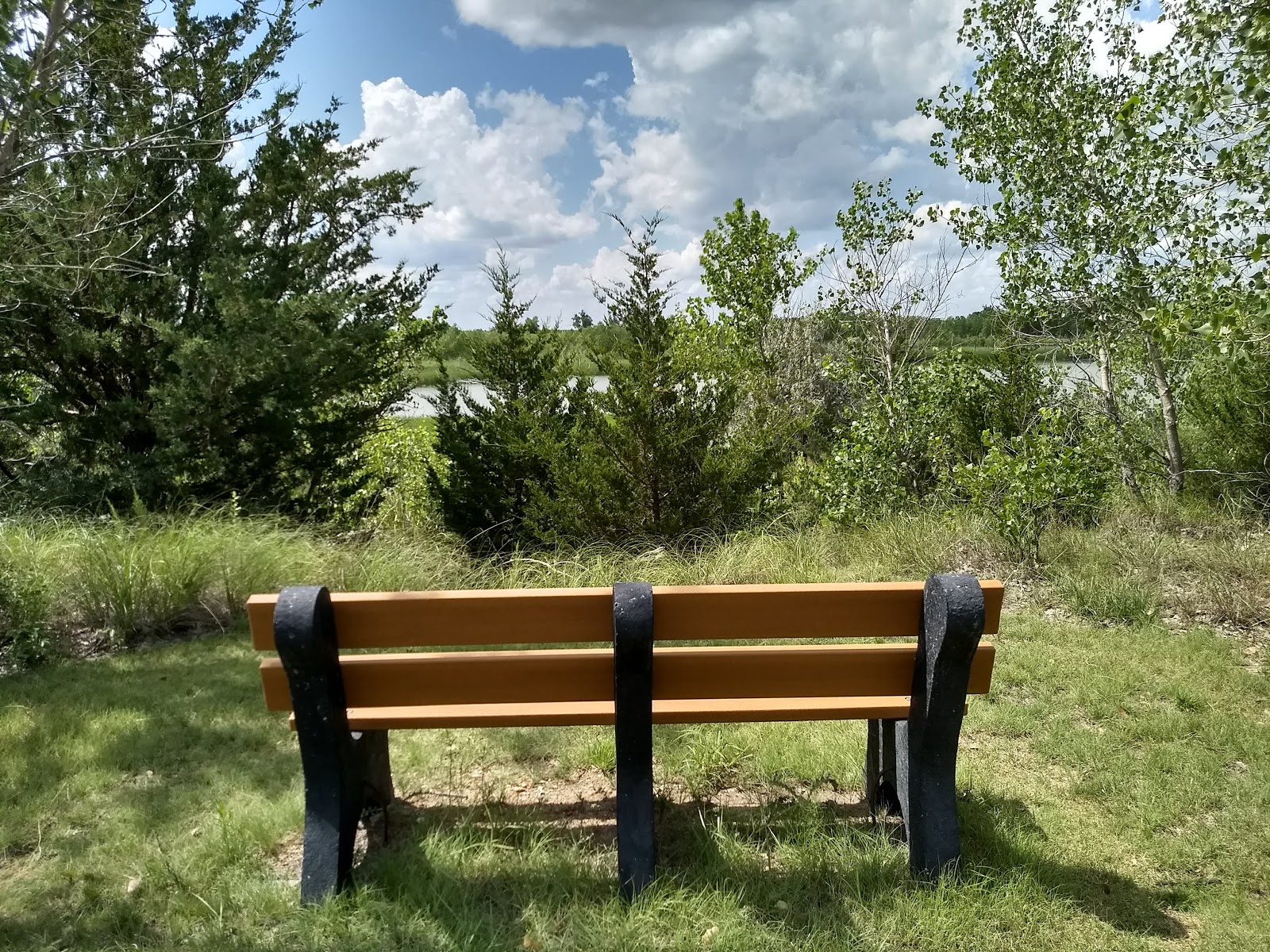
A bench to enjoy the view of the reservoir: once they cut the pine trees
in the park that ran along the reservoir and into the prairie and took that, and discovered that the section of the park with the bluffs was several miles away on the trail. In search of the Threshing Machine canyon, it seemed that there were no clear directions online, and no one seemed to know where it was.

Kansas really needs to get its tourism act together. No signs, and people who should be there with answers have no clue.

But it is a beautiful state with farms, prairie, wildflowers and sky that goes on forever. Pictures are here: https://photos.app.goo.gl/CqVbwRUkbirDMGaw9

Monday, July 30, 2018

Up and down, up and down 7/30/2018

Our next stop was to be in Englewood, CO, where we would stay while visiting family nearby. It has been 2 years since I had seen my brother, Larry and his wife, Rose.  It was great having the opportunity to catch up. To get to the Denver area, we had to go over 4 mountain passes: Monarch at
11,312 feet, Trout Creek at 9346 feet, Red Hill at 9993 feet, and Kenosha at 10000 feet. Monarch, at the Continental Divide was the wildest, with inclines and declines of up to 7% on both sides, and a bit of rain and hail. Ray did a superlative job maneuvering the RV and car up and down without either blowing the engine, or demolishing the brakes.


_________

On to Kansas

The rough weather in the form of strong storms that had been predicted for our day of departure from Denver, missed us completely. Thank you, God! The prospect of strong winds and hail was somewhat disconcerting. But the ride through the last 3rd of Colorado, and the first quarter of Kansas was uneventful. We watched as the GPS recorded our descent from over 5300 feet to 2400 feet elevation. We're staying in a park right off the Interstate in Wakeeney, KS.

Friday, July 27, 2018

Black Canyon 7/27/2018

The ride from Provo to Montrose, CO was absolutely beautiful--mountains and wide open high
plains, punctuated with the sight of a herd of antelope grazing in a field.  The road took us through several small towns, as we played the "Guess That Population" game.  Helper (pop. 2095), Price (gorgeous canyon here) (pop 8371), Wellington (pop 1609), and Thompson, UT (pop 39) are a few.

Our destination was Montrose, CO, home of Black Canyon of the Gunnison National Park, and of our campground. It's called the Black Canyon because it's so narrow and steep that the sun doesn't reach some parts of it, making it look black. From the campground to the entrance of the park is about a 20-minute drive. 

The first full day of our visit here, our plan was to drive the canyon rim road, and take all the walks to the rim. Depending on how long that took, we would either go back to the RV after the Rim drive, and return in the evening, or just stay in the park for the evening program. Because the park is not highly developed and has a very low ambient light threshold, it is an International Dark Sky Designated place. What  makes it very special to me is that is was the first place I ever saw the Milky Way (back in 1975). We camped here in a tent back then. We may have changed, but the canyon hasn't. So we eagerly looked forward to the evening program that would show off the "star" attraction with high powered telescopes. 
Superlative words don't adequately describe the beauty of this canyon. Even the best photographs fall far short of showing how steep, how grand, how deep the canyon really is. One cliff here, at 2300 feet is the highest in Colorado. If the Empire State Building stood on the canyon floor, it would reach slightly more than halfway to the top of the cliff. The face of that cliff is called The Painted Wall, seen in the photo to the right.

Most of the viewpoints here are a short walk from the road--200 yards to 1 1/2 miles round trip. All offer stellar views of the canyon. The last stop on the Rim Road presented us with a wonderful trail that took us to expansive views of the Uncompagre Valley on one side, and the Black Canyon on the other. By the time we were done checking out the rim views, it was about 4 pm, and
we opted to take the East Portal Road that heads down to the Gunnison River. That road consists of successive hairpin turns, with some sections at a 16% grade. We hesitated at first, but then decided to go for it. We're so glad we did!

From the bottom of the canyon, you get a whole different perspective. And it was here that we found the perfect, quiet spot to sit and contemplate the exquisite beauty that surrounded us. We broke out the lawn chairs and cracked open a few beers. 

It was hard to tear ourselves away, but we did, so we would have time to ascend the East Portal Road and get to Sunset View, a spot along the rim road where you can watch the sun go down over the canyon.  What made this sunset wonderful was that the small crowd assembled here watched it in almost reverential silence. Sweet!

By the time the sun had completely set, and the colors of the sky were fading, it was time to head over to the star show. BUT...there would be no stars on display that night as the clouds rolled in.

No matter. The Canyon was fabulous. Here are some photos we took: https://photos.app.goo.gl/BJspZTXniHx1bUqH6

Provo Canyon 7/27/2018

Monday's foray was a short drive from our campground to Provo Canyon. Ray had found what sounded like an interesting hike whose highlight was lots of wildflowers. Having hiked in National Forests before, we assumed that we would just follow the signs for the trails.

The trail we would start on, trail A, was an "out and back" trail. But we could make a loop hike by going to the trailhead for trail A, following that to trail B, and then to the junction for trail C, which would take us back to the trailhead. Unfortunately, the directions Ray got had no distances by which to gauge where the trail junctions were, and, as it turned out, there were no signs at the junction of trail A and B. With no one else on the trail, we had to guess where we should make the turn for trail B. Fortunately, we were able to make a more informed guess with a trail mapping app on my phone that showed us the track we were on.

Anyway, we hiked through aspen forest and mountain meadows replete with all kinds of wildflowers, as advertised. But a significant section of the trail took us through a dense area of shoulder-height ferns that was home to clouds of mosquitoes. The 2-foot wide trail here consisted of powdery dust and loose rocks, as the trail rose and descended steeply. Needless to say, this was not my favorite hike ever.

Pictures are here: https://photos.app.goo.gl/VserBqVnnYCgTCrH7

Thursday, July 26, 2018

The Golden Spike 7/26/2018

As we headed to Provo, UT from Twin Falls, ID, we decided to stop at the Golden Spike National Historic site in Promontory, UT, northwest of Salt Lake City, about 20 miles south of the interstate. I was not expecting it to be as interesting as it actually was. The visitor center has a comprehensive and fascinating look at why the transcontinental railroad was needed, how it was built, and the ramifications of having our country's coasts joined by railroad.

In May 1869, the Union Pacific and Central Pacific railroads met at Promontory Point in Utah, changing the country forever. We saw replica trains re-enact the meeting of the two. One train puffed white smoke, the other black. The train from the west used what was an abundant source of fuel in California, wood, the one from the east used its main fuel, coal. The last ceremonial spike driven was the Golden Spike, which was then replaced with an iron one. The original Golden Spike is on display at Stanford University. The gentleman that drove that last spike was Leland Stanford, the president of the Central Pacific railroad, and at the time future founder of Stanford University.

Pictures are here: https://photos.app.goo.gl/8CHQNjye1VbSbMdC8

Sunday, July 22, 2018

Hawks along the road 7/22/2018

Perrine Bridge over the Snake River
There are many trails in and around Twin Falls, most following the Snake River canyon rim. After a leisurely morning, we headed out to check some of them out. We went to the Perrine bridge, a bridge in Twin Falls that carries U.S. Highway 93 over the Snake River Canyon, connecting to Jerome County and I84. It's the 8th highest bridge in the US, and is named for I.B. Perrine, who pushed for 20th century irrigation projects in this area, and is credited with founding the city of Twin Falls. The Perrine Bridge is a popular basejumping site known all over the world and may be the only man-made structure in the United States where basejumping is allowed year-round without a permit. Jumpers often use the nearby visitor center as a home base before and after parachuting from the bridge.

From the visitor center there, the views of the canyon are impressive. You get wonderful views of the private Blue Lakes Country Club and the curving Snake River, as well as the bridge.

We walked along the canyon rim trail for a bit, then  decided to drive up to the Minidoka National Historic site near Jerome, ID outside Twin Falls. In 1942, President Roosevelt signed an Executive
Order requiring over 110,000 Japanese people to give up their homes, farms and businesses, and be brought to detention centers. For the rest of World War II, they remained there. Over 13,000 of those were imprisoned at Minidoka. This historic site presents the story of what happened here, and gives it a human face. Two thirds of the people who were brought here were Americans, and they lived American lives and swore allegiance to this country. While here, they formed boy scout and girl scout troops, a jazz band, art clubs, organized churches, planted gardens. The kids played marbles, jacks, jump rope--they lived American lives. In August 1943, Minidoka firefighters helped subdue a wildfire 60 miles from camp. The history of this place is so bizarre--Americans imprisoned for how they looked--it's hard to believe it actually happened. We can't ever forget this.

Minidoka is located on the outskirts of Twin Falls, in an area that is mostly agricultural. Once you are outside the hub of the city, there are farms everywhere. On our way to Minidoka, I had noted a hawk sitting on an irrigation rig by the side of the road. Then, on our departure, I noted several hawks sitting on that irrigation rig. We stopped the car, and looked back at the field we had just passed. There were at least 50 hawks perched on the irrigation rig in that field. We took some pictures and moved on. Later, I identified the hawks we saw as Swainson's hawks. The information I dug up on these hawks is that they favor wild prairie, hayfields, and pastures over wheat fields and alfalfa fields, which may offer its prey too much cover. They require elevated perches for hunting and a supply of small mammals such as young ground squirrels as prey for its nestlings. "Many still-hunt, watching for prey activity from a perch such as a tree, bush, pylon, telephone pole, hummock or other high object.These birds patrol open areas or scan for prey from a perch; they may also catch insects in flight. They take advantage of insects turned up by farm equipment or driven out by fire." Those hawks strung out on the irrigation rig were quite a sight to see. We caught a few pictures of them.

After our visit here, we decided to return to Shoshone Falls, where there is a trail that leads to the place where Evel Knievel tried to jump the Snake River Canyon (and failed). We hiked up the trail for a couple of miles, following switchback after switchback, up and up, til we were almost at the top of the canyon hills. But we saw no such place, although we were assured it was there. No signs, no markers. It was hot and it was getting late. Though the views of Shoshone Falls and the canyon were wonderful, we decided to pack it in and go home for a beer.

Saturday, July 21, 2018

Down the Snake River--Twin Falls 7/21/2018

Shoshone Falls
Twin Falls, ID is a smallish community in southern Idaho, a gateway to the Snake River Canyon, which lies to the north. The drive from Hells Canyon took us back along Route 71, for us, that notorious hairpin turn on switchbacks that drop off to steep cliffs. We found that driving it at the beginning of a multi-hour drive, rather than at the end, made it much easier to traverse. The scenery was just as spectacular going as it was coming. On the way down, we did pass a short stretch of road that was covered in black blobs. I thought at first they might be rocks, but then I noted that they were moving! They must have been mormon crickets. This is a picture from the web, but it shows the distribution of the crickets on the road.

On the way through Cambridge, ID, population 316, (not to be at all confused with Cambridge, MA), we passed this little gem:
Wouldn't you love to stay here? No phones in the room, or cell service, but you can use the pay phone (maybe) out front. One thing we came to have some trepidation about were the many "Open Range" signs along back roads. Where there are "open range" laws, people wanting to keep animals off their property must erect a legal fence to keep animals out. So cattle will roam wherever they wish in "open range" country. There's nothing quite like driving your RV pulling a car around a narrow hairpin turn down a mountain to find cattle in the road. Surprise!!

One odd thing about where we were staying for the last several days was the time zone issue. Our campground was on the Oregon side of the Snake River, in the Pacific Time zone. Drive across the bridge, and you are in Mountain time. Without a cellular network, our phones always read Mountain time, the last signal they had before dropping off the network. When we left the campground to come south, and we finally had a signal, our phones added an hour. What? Where did that hour go??

After a few hours, we finally got back to I84, the first time we had been on the Interstate in weeks. Our stop was in Twin Falls at a campground owned by a former HP engineer and his wife. He suggested we see Shoshone Falls (only 10 minutes away) in the evening as the sun was setting, so we did. Here are some pictures, most taken by Ray: https://photos.app.goo.gl/UtvUDAk3YiNdddeD7


Wet and Wild on the Snake River 7/21/2018

Thursday we set out to the dam again for our jet boat tour. The day was forecast to be hot (upper 90s), dry, and sunny--common for this area. We lucked out in that this tour only had a total of 8 people, including us.The jet boat? What a hoot! Both Ray and I got soaked going through the class 4 rapids.

We stopped at a small sandy area along the banks of the river to dip our feet in the water, or take a quick swim (2 adults and 2 kids actually swam in the cold water--not as cold as Bear Brook State Park in NH in the summer). And we made another stop to see ancient Indian pictographs on the rocks on a small trail up from the water's edge.

2 of the adults on our tour were on a 2 week tour of Oregon, and were from Germany. They had each come to the US as exchange students, he in Texas, she in NJ. They met and married in Germany, and for the last several years have traveled to the US each summer. The young man mentioned that as someone who lives in northern Germany, he has never visited southern Germany, and doesn't know much about it. Sounds like a lot of people in the US.

At any rate, the jet boat ride was great. We'd love to do this again sometime.
Pictures here: https://photos.app.goo.gl/TCVfxsn9BsECsr7M9

The Eagle Has Landed! 7/21/2018

Our campground is operated by the Idaho Power Company and is located on the banks of the Snake River, about 22 miles (45 minutes) south of the Hells Canyon dam on the Oregon side of the river. It's lovely and shaded, and really in the middle of nowhere. There is no cell service at all, and there are no TV stations that can be picked up by antenna. The campground offers paid wifi, of which we have taken advantage. (The down side being that you get logged out after 15 minutes, and have to log back in) With 2 days scheduled here, we decided to check out the road to the dam, the place from which we would embark on our jet boat tour tomorrow. That was another winding, narrow road, this time, following the curves of the mountains that flank the Snake River. At one stop to enjoy the scenery, as I exited the car, something caught my eye. Flying up from the river, not 30 yards away, was a bald eagle. We watched it soar for a few seconds, and then it landed on a rock a short distance down the road, maybe 30-40 yards.

It sat there until another car came along and stopped. A woman got out, and started approaching the bird, prompting it to fly away. As she walked away, she acknowledged that she had made a mistake, calling back to us "Yeah, I'm an a****le." Seeing that bird so close in its natural habitat was awesome.

After driving the road to the dam, we decided to investigate another viewpoint of the canyon, about 35 miles north of the campground, and about 4000 feet higher in elevation. The temperature up there was 13 degrees cooler than down at the campground.The access road was, of course, narrow, and winding. But what a fabulous view at the top! You couldn't really see
View from the overlook
the river from the observation point, but the mountain view was stunning. The meadows up there were covered with red indian paintbrush, hyssop, and clover, as well as many other yellow, red, purple and white wildflowers. There were very few people there, and the silent beauty of the place was inspiring.

Pictures are here: https://photos.app.goo.gl/FAwXwPwLwyn7WpWa8

Friday, July 20, 2018

Ray and Carol's Excellent Adventure--the long and winding road 7/20/2018

Route 12
NH has route 101 and Route 93, Massachusetts has I90 , I495 and I95. Florida has I75, I4, and I95. Every state has a main north-south and/or east west road. Idaho has Routes 12 and 95. Do not confuse 95 with I95.

We knew seting out that it would be an interesting drive to get from Missoula, MT to Oxbow, OR, when Garmin (and Google) said it would take 7  hours to go 350 miles by car. With construction delays, and with the challenges of maneuvering a 28 foot RV pulling a 15 foot car, it actually took 8 hours. We knew that the 2-lane roads we would be traveling were designated "scenic". But the "thrill" is all in the experience of it. We started in the mountains that rose steeply from the Lochsa River on one side, and the road (Route 12) on the other. We wound around curves, climbing 6-7% inclines and descending those hills for 137 miles, and passing through 0 towns. We missed the turn we should have taken in Kooskia, ID, and knew we were in trouble when Garmin directed us to turn at MT 162,
Nez Perce reservation--wheat fields and harvester
and drew a route down MT old route 7. I get nervous whenever we have to take the RV on roads designated "old". As it happened, the route took us through the Nez Perce reservation--beautiful wheat fields on rolling hills. If you went to nowhere, drove 60 miles in any direction, took a left, and drove another 30 miles, that might describe this route. We had very little company on the road. But it was more ups and downs and curves. Finally, we arrived at route 95, Idaho's main north-south route on the west side of the state. What did 95 look like? More ups and downs on extremely steep, curvy roads.

The last turn for us was at route 71, a road that
would take us to our campground on the Snake River. We thought: "Awesome, this road looks straighter than 12 or 95!" Nay, nay!! If it's possible, 71 was curvier and steeper than the other 2 combined. Admittedly, it took us through some fantastic scenery, with views down to the Brownlee dam. But, wow! What a drive! Here are a few pictures from the drive--all through the windshield--there was no place to stop!  https://photos.app.goo.gl/GDfAfBATaw6SgVya7

Wednesday, July 18, 2018

Bison 7/18/2018


We said goodbye to Glacier, and went south to just north of Missoula at the National Bison Range. The 18,500 acre range was established in 1908 to support a population of American bison. As one of the oldest wildlife refuges in the US, it is home to about 350-500 of these animals, as well as bear, mountain goats, bighorn sheep, elk, deer and many other animals, including about 200 species of birds. The range is open grasslands, and has an incredible quiet, peaceful beauty about it. To drive the park road, we had to unhook the car from the RV because the road is narrow and steep. Pictures are here: https://photos.app.goo.gl/iJoUZPAzUawAfaNh6

Friday, July 13, 2018

Goats, sheep and killer views 7/13/2018

Click the photo for enlarged view
We made the correct decision today about getting to Logan Pass for our hike on the Highline trail. We drove to the St. Mary Visitor Center, parked the car, and took the park shuttle up to Logan Pass. Again, we lucked out on weather, starting in the high 60s and warming to the low 70s, with a refreshing, but not overpowering breeze.

The Highline trail is a relatively easy trail, that gains only 825 feet over 3.6 miles (total 7.2 miles round trip). At every step, and every turn, you have absolutely spectacular scenery as the Highline follows along the Continental Divide, also known as the Garden Wall in this area. The exceptionally beautiful views, the excellent opportunities for spotting wildlife, and the wildflowers, all combine to
That's Ray on the trail
make this an awesome hike. At roughly one-quarter of a mile from the trailhead you get to the famous ledge with the reputation for terrifying those with a fear of heights, us. In most places the ledge, hanging like a shelf along the Garden Wall, is only six to eight feet in width, and has drop-offs of roughly one hundred feet or more down to the Going-to-the-Sun Road below. This segment lasts for only three-tenths of a mile, though. Fortunately the National Park Service has installed a hand cable along this stretch of the trail.

The rest of the trail offers spectacular views as the trail continues to hug the cliffs. We may have a new favorite trail here...We did encounter a mountain goat that ambled along the trail, munching vegetation as he proceeded. He came so close, we could have pet him. We couldn't get out of his way
as the trail was barely wide enough to accommodate us. Then, towards the end of our hike, we came upon a small herd of bighorn sheep grazing in the meadow. The pictures tell the story:
https://photos.app.goo.gl/DsY2ciUQzDys2y3AA
The capper of the day happened during dinner at a local restaurant. They keep doors and windows open, which was an invitation to a bat that was cruising the neighborhood. It went fluttering around the dining room and then scooted out the door.

Thursday, July 12, 2018

Around the lake 7/12/2018

Today we drove south to the Two Medicine section of Glacier, about an hour south of St. Mary where we are staying. After making the turn on Route 49, the road takes you up a rough winding road to a spot that looks over the Lower Two Medicine Lake. The views are spectacular. We continued on to the North shore of Two Medicine Lake where we picked up a trail. After 2 days of longer trails, we decided to rest our feet with a shorter 4 mile hike.  Again we lucked out with cool, comfortable, blue-sky weather, perfect for hiking. As with other Glacier trails, the views were beautiful (of the lake, mountains and wildflowers). We usually stop to eat lunch somewhere along the trail, but decided not to do that as the trail was posted for bears that frequent the area.

We stopped on our way back north at that overlook on Lower Two Medicine Lake, and discovered 2
crosses off a small spur trail there. They were both memorials for Blackfeet Indians whose ashes had been scattered there. A more beautiful spot to send your ashes to the wind doesn't exist. Photos are here:

We opted to get dinner at the Two Sisters Cafe, a small restaurant just north of our campground. Great food, great service.
This photo of Two Sisters Cafe is courtesy of TripAdvisor

Bears and moose 7/12/2018

Our full first day at Glacier, we had planned to hike the Highline trail to Haystack Pass, a 7.5 mile trip that takes you along the Continental Divide. We drove up to Logan Pass where the trail begins,
but the was absolutely no place to park the car. They were turning people away from the parking lot up there. We could have driven down to a lower area and taken the shuttle back up, but it looked like there were many people already waiting for the shuttle, that arrives every 30 minutes or so. So we opted to take the St. Mary Falls/Virginia Falls hike, what turned out to be about 8 miles. It was a very windy day, with winds gusting to 25-30 mph--ultimately, a crucial fact for us. At any rate, we set out, and were struck by the number of people on the trail. We'd taken this trail before, and never encountered this many people, to the point that it seemed like we never were out of sight of other people on the trail. The scenery was still spectacular, though, and St. Mary Lake is still a blue-green gem.

We were amazed at the difference in vegetation on this hike from the last time we were here, in 2016. In 2015, there had been a large fire that had wiped out the trees from this section of the park. But in 2016, there were abundant colorful stands of wildflowers carpeting what had been the forest floor in all different colors. It was breathtaking. This year, 3 years after the fire, thimbleberry blanketed the area. We learned that this is evidence of the ecological succession after a fire.

When we came back from our hike, we discovered a huge error we'd made. We had left our awning out--not a smart move, with strong winds whipping. It shifted the plastic cover on the awning so it doesn't roll up correctly (the cover not the awning). Oh well, live and learn.

_____

Wednesday was Iceberg Lake trail (10 miles) day. We set out for Many Glacier area of the park, taking a dirt back road. A few miles down the road, we saw a large black bear in the middle of the road. at least 100 yards away. Even at that distance, we could tell he was large because he had really long legs. When he saw us, he scooted into the woods. 

Iceberg Lake trail was  as gorgeous as ever, and the weather was perfect--we started in the high 60s,
and it warmed to the low 70s. The pictures tell the story. We did see a moose reclining in the snow  down off the trail. That was pretty cool.

We got back from our hike just in time to make the evening
presentation of the Blackfeet Indian dancers at the visitor center. It was awesome. The Indians explained the dances and the costumes they wore, and showed us 8-10 different dances. It was wonderful. They do this every Wednesday evening during the summer at the St. Mary Visitor Center.

Pictures of Iceberg Lake are here: https://photos.app.goo.gl/NhnBx2Xban3KrMz49
Pictures of St. Mary are here: https://photos.app.goo.gl/yKjDUke2oDRmHKhX6

Sunday, July 8, 2018

Great Falls, MT 7/7-8/2018

Across the tallgrass prairie to the shortgrass prairie, we headed toward Montana. In Great Falls, we are staying in a KOA  not far on the outskirts of town. We set up, had a glass of wine and dinner, and then took a walk in the cooling evening. The campground hosts an entertainer named Richard Bird

Baker and his playing partner, Diane Stinger, who perform bluegrass, country, hillbilly, cowboy, civil war and a dozen other genres of music. So we wandered over there to listen. They were wonderful! This video is a sample of what we heard. https://photos.app.goo.gl/MyagaSC75EQJXvzp6
We enjoyed at least an hour of their unique sounds.


Sunday was laundry day. When we travel like this, I'm reminded of how lucky we are to have a washer and dryer at home. I really hate laundromats, but this was not one of the more obnoxious examples, and we were done in a reasonable amount of time.

We spent the afternoon at the Lewis and Clark Interpretive Center in Great Falls, a place that explains the fascinating and immensely historically important journey of Lewis and Clark. From there we took
a few local farm roads to overlooks along the Missouri River to see the falls. When Lewis and Clark arrived at this point in their trip down the Missouri, they had heard from the local Indians that they would encounter waterfalls. They subsequently planned for one day to portage (carry their boats) around the falls. What they actually found here were 5 sets of gigantic falls. They had to carry their 6 boats 18 1/4 miles, and it took a month. We love being in these places that let us touch US history.

Photos of Great Falls here:
 https://photos.app.goo.gl/53BaGKsPbNDiWhEG8

Badlands 7/8/2018

I can just imagine how amazed the first non Native Americans were when they first set eyes on the Badlands. After traveling for miles through rolling hills and plains, the Badlands rise up from the landscape--jagged rocks, and non-fertile soil.

We spent 2 days here, hiking and driving the park. On Wednesday, we took a 4 1/2 mile hike that took us through wildflowering prairie with great views of the Badland rock formations. Upright prairie coneflowers, showy milkweed, verbena, sunflowers, and thistle were among the many wildflowers in
large stands along the way. It always seemed like someone took the time to plant a garden for us, as we hiked past them. The fact that no one else was on this trail made it extra enjoyable, and the weather was superb--in the 70s and dry. We took a few more short trails to overlooks, and headed back for a beer. In the evening, we headed over to what was probably one of the best town
fireworks shows we have ever seen, in Interior, SD, about 4 miles away from our campground. There were lots of fireworks, and the show lasted for 25 minutes. The mosquitoes were pretty active, and we both got a few (or more) bites. Love this country--it was a happy Independence Day.

The second day we drove the park road and took a few small walks to overlooks that all provided spectacular views. We decided that we did want to further explore the road from which the previous day's trail departed. This was a gravel road that is very infrequently (we later found out) taken by

anyone. This was a narrow grave road that parted the prairie. We passed a group of cattle gathered by a fence, and inexplicably also on the top of a small mesa-like table. How the heck did they get up there? Further along the road, after about 5 miles, we saw a small tidy house, obviously occupied, with other farm buildings and vehicles. Out front, proclaiming to all the world passing by (?!), was a sign hand-painted in red, white and blue: Make America Great Again. We had already passed it, (with no hope of turning around on the narrow road), before I knew I should have snapped a picture of it.
Photos of day 1 are here: https://photos.app.goo.gl/DCkcvVBbuNBAiqvn6
Photos of day 2 are here: https://photos.app.goo.gl/xuuopHWSRMPiSgoy7

Friday, July 6, 2018

Monowi, NE, real America 7/6/2018

The tavern
After a quiet and restful night, and a couple of cups of coffee and breakfast, we were off to today's much-anticipated highlight: Monowi, NE. The Interstates are wonderful. They allow us to get from one place to another with relative speed and efficiency. But thee's nothing like back roads. Back roads are where America is. And it was 2 1/2 hours of beautiful, rural South Dakota and Nebraska back roads that brought us to Monowi, Nebraska. Located just south of the South Dakota-Nebraska state line and of the Missouri River in northeast Nebraska, it is a place that has the distinction of being the only incorporated town in the USA with a population of 1, Elsie Eiler.

In its peak years of the 1930s, it had a population of 150. Like many small communities of the Great Plains, it lost its younger residents over the years to the cities. During the 2000 census, Monowi had a population of 2, Elsie and her husband, Rudy, who died in 2004. Now as the only resident, Elsie, 84
years old, acts as mayor, granting herself a liquor license and paying taxes to herself. She is required to produce a municipal road plan each year in order to get state funding for Monowi's 4 street lights.

We arrived at the tavern mid-afternoon. We almost blew right by the non-descript little tavern, but Ray saw a wide driveway, and pulled in. Elsie was occupied with photographers from a NYC ad agency that had benn producing a documentary for Prudential Insurance. Yes, she's famous.

We had a few beers and a chat with Elsie. She told us that the building we were in had been built at the turn of the 20th century as a 2 story building. Some time later, the bottom was eliminated and the top was left. That was the tavern. We talked about the history of the building. In 1971, she and Rudy opened the tavern there. She cleans, cooks the food (burgers for $3.50), serves the customers, and loves her life. She has 2 children, a duaghter in Tucson, and a son who lives south in Nebraska.

It was a really cool visit, and probably will count as a major highlight of this trip. Pictures are here: https://photos.app.goo.gl/NJhdn9GE1tziAepm6

Wednesday, July 4, 2018

Wind! 7/4/2018

Wind!

After visiting our friends, the Gorgogliones, in MN, we headed west. We rolled past miles and miles of corn and soy beans, and rolling MN landscape. We passed 2 large wind farms, one in the vicinity
of Dexter, MN. The Grand Meadow wind farm is 6 miles x 4 miles, over 10,000 acres with 67 windmills. The Nobles wind farm is 7 miles x 8 miles. We learned that windmills start turning with a 9 mph wind, and are at full output at when the wind is at 27 mph. They shut down with a wind of 56 mph. Ther are heaters (not on the blades, though), in various locations, to enable the windmills to perform down to -27 degrees F. In winter, ice build up  causes a reduction in power output. And there's a reason these windmills farms are here: the wind. It was whipping at 20mph pretty much all day.

Our route today took us off the Interstate up route 23 in MN, a 2 lane road where the view of cornfields was to the horizon.

We visited Pipestone National Monument, a place where Indians quarry for pipestone, a reddish type of mudstone. They have taken this rock from this place for many centuries to fashion into pipes and
figurines. Even now, only American Indians enrolled in a tribe recognized by the US government are allowed to quarry here. For these Native Americans, this is a holy place and the rock is sacred, simiar to the status of the cross and Bible in Christianity. This place is so sacred that warring tribes from long ago ceased hostilities when they came here to get the pipestone. No one was allowed to camp here.

The monument itself is comprised of a trail that winds through tallgrass prairie past ancient quarries and along a stream that crashes of a waterfall. Because of recent heavy rains, the stream had flooded, and parts of the trail were closed. There were prairie wildflowers everywhere and the scent of sweet clover filled the air. This place has a wonderful sense of peace about it.

Our stop this night was in Larchwood, IA, the Grand Falls Casino. To get there, we drove for miles through the aforementioned corn and soy bean field country, with the wind whipping. After an hour, all of a sudden, there it is, the Grand Falls Casino: a modern casino, golf course, conference center, hotel shopping mecca--and campground. No doubt, the campground is there for people who might come to gamble. As a traveler's rest spot, it excels. It has 10 pull-through
sites with full hookups, and it is a short (but sufficient) walk to the casino. Here too, the wind was incredible. When I exited the RV to check in, I opened the Rv door, which promptly blew almost off its hinges. From our campsite, we could watch people tee off on the golf course!  Photos of the day are here: https://photos.app.goo.gl/JTrBm9hYeevbRdWH6

Sunday, July 1, 2018

To Minnesota 7/1/2018

We decided to take a scenic route towards Minneapolis, where we will visit with friends. We drove
along the Wisconsin, and then the Mississippi Rivers through small town Wisconsin, Absolutely beautiful country. In many places, the rivers overflowed their banks to low lying treed areas. If you're not in a hurry, a 2 lane back road beats the Interstate any day.

Last night, strong thunderstorms blew through Iowa and Minnesota, and some just a few miles south of where we are staying in Rochester, MN had winds of 75-85 mph. We had heavy rain, thunder and lightning, but no damaging winds.