Thoughts Become Things

Thursday, July 22, 2021

Little River Canyon drive--snaky road fun


Just south of DeSoto State Park is Little River Canyon National Preserve, a place where the Little River cuts through the landscape and has created the deepest canyon east of the Mississippi. There is a scenic road that runs along the northern edge of the canyon and connects to another on the south side to create a loop. We took the day to drive those roads yesterday. We stopped at all the overlooks, many of which were overgrown with vegetation, obscuring the view. There are warning signs at all intersections (there weren't many), that prohibiting trucks, trailers, RVs and motorcycles from using the road. In some places, the road is so steep and winding that we had to proceed in first gear. It was not unusual to go up an incline, and be met with a sharp curve at the apex of the hill, and a sharp decline around the curve. At one point, we did just that, and were confronted with a place where half the road had washed out. It was definitely a fun ride.

We stopped at the Little River Falls and the beautiful Canyon Center there, a place that offers many educational programs. The Trail of Tears, the route over which Native Americans were driven from their ancestral homelands from 1830-1850, cuts through the falls area. 

Our visit to Alabama has been something of a revelation. Probably because we have mostly driven the gulf area of the state, we had the impression that all of Alabama was flat. In fact, it is home to the southernmost Appalachian Mountains. 

Pictures here: https://photos.app.goo.gl/tQFAXGZMEr4hzLm57

DeSoto State Park: Rain and peace

We headed out of Cheaha under cloudy skies. Our first order of business was a gas fill up (a real score at $2.64.9 a gallon). A 65 gallon fill up makes every penny per gallon count. Next we did grocery shopping.


Then, on to DeSoto State park in northeastern Alabama. Driving north from Cheaha, we traveled through more Alabama rural country--curvy roads, lined with forests and farms. We were surprised at the sheer volume of litter we saw in the ditches along these roads: cups, bottles, plastic bags, papers etc. (You get a really good view of that sitting this high off the road.) The weird thing is that these were rural roads with very little traffic. It leads us to believe that no one has picked up litter on these roads in a very long time. Another feature of our drive was the large roadside areas blanketed with kudzu. We could see the lumpy forms of trees and bushes under the uniform kudzu blanket that sometimes reached 20-30 feet high.  The kudzu ultimately kills the vegetation it covers.


Our campsite at DeSoto State Park is wonderful. Sites here are widely spaced, very private, and have all utilities (water, sewer, electric) and cable TV as well. We've never been in a state park that offered cable TV before. Unfortunately, like Cheaha and Florence Marina State Parks, there is no cell or data connectivity here. But it is blissfully quiet. One minor quibble is that our site is covered in a fine gravel that, when wet, sticks to everything. So it tracks everywhere, and is difficult to keep out of the RV, even though we've tried. Our site is located right next to an access
Trail access via spur directly behind our site

point to a trail we decided to take, and that leads to 2 small waterfalls. It rained hard last evening after we set up, and last night, so we expected the falls and creeks to be running. As it was, the trail was very wet, and water ran freely down the center of the trail in places. We stepped through and around creeks. At one point, Ray lost his footing on some wet leaves on wet rocks, lost his balance, and landed on his butt. 

About 2/3 of the way along the trail, it started to rain. Because of the dense forest cover, it didn't affect us too much. We were back at the RV by early afternoon. After lunch, Ray decided to add some air to our RV tires, a somewhat more involved process than on our car (for a number of reasons). After that, we headed down to a boardwalk built into the forest. Just as we arrived, it started to pour. We took out our umbrellas and took a peaceful, pleasant stroll in the pouring rain. We stopped for a bit to sit by ourselves under a gazebo in the quiet of the forest and listen to the rain on the trees.

More photos here: 

Cheaha State Park

Cheaha State Park is the oldest state park in Alabama, and site of the highest point in the state. It is located in east central Alabama, due east of Birmingham. This was our next stop. We took mostly

Kudzu  covers everything

secondary and tertiary roads to get there, so the ride was interesting and scenic. Kudzu was everywhere, and roadside ditches were, in many place, strewn with trash. The closer we got to Cheaha, the more the roads ran up, down, and around hills. We missed the miniscule and fading sign that directed us to the turn off for the park, and on a narrow, 2 lane road, had to drive miles down the road to a place where we could U turn without dropping our wheels into a ditch.

When we arrived at the campground to check in, we were given a map of the campground itself. If we wanted a trail map for the park, we'd have to pay $2 for it. The "trail map" that we paid for wasn't helpful at all, as it showed some of the main trails, but not all. There were no descriptions of the trails with information like length, difficulty, or elevation gain. This was to be a sign of things to come.

For dinner that evening, I set up the instant pot outside and connected it to another outlet on our power post. So we had instant pot ribs for dinner! Very cool.

The next morning, after rain overnight, we slathered ourselves with bug repellent, and took a trail to a viewpoint that overlooked the lovely Talladega Forest. When we arrived at the viewpoint, fog shrouded the view. Within minutes, though, the fog lifted and revealed an expansive view of forest, lakes and hills.

We then headed down to Cheaha Lake to have lunch. Next up, we decided to take a hike to Cheaha Falls. But nowhere on the map we were given did it locate the trail, and there is no internet or cell service in lower elevations of the campground or park. At higher elevations, it was possible to get a shaky connection. From that connection, we finally got an online trail map, and directions to the trailhead. Once there, we set off, and after about 1/4 mile, came to a fork in the trail with no signage or indication of which way to head. Naturally, we took the wrong fork, a fact that we realized a bit later. We the retraced our steps to the correct path where there were no signs, trail blazes or cairns to mark the way. 

Fortunately, we made it to the falls, a lovely rocky area tucked away in the woods. Along the way, I


noted oak leaf hydrangea and many other wildflowers.

On returning from this hike, we stopped in at a Native American museum at the park. It exhibited a large arrowhead and artifact collection of a local man. This man hunted for and collected a few thousand arrowheads in northeastern Alabama. The collection was given life by the ranger who staffed the museum, someone who obviously had a passion for Native American history and life. He explained to us how the different types were made, and why some were rare and important. This was an interesting stop.

Our last visit of the day was to the highest point in Alabama, the site of a fire tower built by the CCC in the 1930s. We climbed the tower to get 360 degree views.

More photos are here: https://photos.app.goo.gl/NeCkhcFQfsGcyecQ9

Saturday, July 17, 2021

Georgia's "Little Grand Canyon"


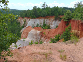
Yesterday's visit was to Providence State Park in Lumpkin, GA which lies on the southwestern border with Alabama. We were surprised to learn that much of the canyon formed due to poor farming practices by early settlers.  Soft soil began washing away in the early 1800s when trees were cleared to  plant crops. By 1850, ditches 3-5 feet deep had been cut into the land. Today, some of them are as deep as 150 feet, and there are 16 canyons over 1,108 acres.


The day was very warm, and very humid, so we took lots of water on our hike. In many places we could see the erosion taking place. We saw trees perched precariously at the edge of the canyon, just waiting for a few more big rains to wash the soil away the holds them on the canyon rim. In one area, we saw a number of rusty old 1950s cars being swallowed up by the forest around them. Due to the environmental damage that removing the vehicles would cause, park officials have decided to leave them alone.

Erosion in the park is ongoing. We could see that the fence that once marked the edge of the trail was now on the edge of the canyon in spots. To keep the trail intact, the park has put down heavy mats and gravel in erosion heavy steeper spots.

More photos here:  https://photos.app.goo.gl/28xCcTKMMAx2QzEq8


Thursday, July 15, 2021

Squeaky sand!

Our route south

Yesterday, we decided to check out some of the lovely towns along the east side of Mobile Bay south of Mobile. The towns of Daphne and Fairhope stood out. Both are distinguished by expansive brick homes with lush landscaping. We were surprised by the hilly topography of this area. The hills were so significant that a bicyclist would have a serious workout traveling the roads. Elsewhere not far from the coast, the landscape is typical southern flat. 

We took a short tour of one of the Daphne neighborhoods. Many of the gorgeous brick homes were built into and around slopes--not what you'd expect along Mobile Bay. As in central Florida, huge, old live oaks and crape myrtles rule the landscape here. Many homeowners have posted home names out on the road, like: "Wright on the Bay", "Sweet Home Alabama", "Bay Daze", and "Happy Ours".

Fairhope live oak tree
We stopped in a town called Fairhope. The previous evening, we saw a story on the local news about a 200+ year-old live oak tree on a bluff over the bay that had been infested with termites. The town had cordoned the tree off, and was considering the question of whether to cut the tree down (!), or spend $10,000 to treat the problem and save it. As we drove through Fairhope, we decided to go find the tree and take a look. It's hard to believe that anyone would consider cutting it down. This tree is fantastic. We learned later that the town decided to treat the tree and save it.

From there, we drove south to the peninsula that
forms the southern end of Mobile Bay and separates it from the Gulf. It's really a sliver of land that felt the brunt of Hurricane Sally that came ashore here with 110 mph winds in September of 2020. It dumped over 20 inches of rain on this area as well. We saw lots of reconstruction here, and some buildings still showing damage from the storm. Many structures have already been resided or reroofed or both. We walked the beach at Fort Morgan, and experienced something we never had before: squeaky sand! The sand made squeaking noises as we walked on it!  We really laughed about this. 

The white sand actually does squeak when you walk on on this stretch of the Gulf of Mexico coast. From the internet: "That’s because the sand from Panama City Beach to Destin to Alabama’s Gulf Shores consists of tiny quartz particles. That fine, sugar-like sand on the Alabama coast has the right shape and make-up to squeak beneath your feet. When we walk over the sand, the particles rub over each other. The air between the grains of sand has to escape. The noise emits from the escaping air and the particles rubbing together." 

On the way back north, we stopped in Fairhope again, and walked out to the end of the 1/4 mile long Fairhope pier and enjoyed the late afternoon. This was a lovely relaxing day.


Monday, July 12, 2021

Southeast tour begins

 Last year, we were disappointed that our trip to Montana and Glacier National Park had to be canceled because Covid concerns had prompted the Blackfeet Nation to close access to their lands. The east side of Glacier National Park falls within the Blackfeet reservation, and so all access to that was cut off as well. We immediately started planning for 2021, and made reservations for a 2 week stay at a campground just outside the park gates. We happily anticipated this trip all year. But the release from Covid restrictions over the past year had people recognizing that RVing is a great way to travel. There was a surge in RV purchases in 2020 of 4-5% over 2019. Anticipated sales for 2021 is 19.5 to 20% over 2020. And all those RVs are cramming themselves into campgrounds, and flooding National Park trails. 

We've been reading the news stories about traffic jams in parks, and conga lines of hikers on trails. This was certainly not the experience we were seeking. We love to be out on a trail in the mountains in the quiet and surrounded by the spectacular beauty of wildflower covered mountainsides and snow capped peaks all around. But not this.

Crowds at Glacier

So, with this in mind, last month we cancelled all our reservations and made different plans. On Sunday we headed north to Alabama and Georgia for a 2+ week swing through what promises to be some beautiful country. Last night we stayed at a nice RV campground in Perry, FL. Tomorrow, we head for Mobile, AL, what has become a favorite place over the last few years.
View at the back of the campground

Our site