Thoughts Become Things

Tuesday, October 25, 2016

Visiting an old friend 10/25/2016

500+ mum flowers all from 1 plant, and on 1 stem!
Whenever we're in the neighborhood (within 50-100 miles), we take the opportunity to stop in to Longwood Gardens in Kennett Square, PA (just north of Wilmington, DE). Every season, every year is different and a sensory treat. This year, we had looked forward to seeing a somewhat revised version of a nighttime light and sound show here that we had seen twice last year. Unfortunately, we discovered that the light show was only offered from Wednesday through Sunday, and we were visiting on Monday. But this was the start of Longwood's Chrysanthemum Festival in the conservatories, and we had never seen that, so we went anyway. Wow! More than 17,000 chrysanthemum plants were grown into ball, spiral, column, and pagoda shapes, and other forms as well. The amazing thing is that these forms are all trained from single stems! Longwood has one of the oldest chrysanthemum collections in North America, consisting of 230 different types. Since we were there early in the festival run, many of the plants were not in full bloom, and the 1000 + bloom chrysanthemum (on 1 stem in ball form) had not yet been put in place. It was going to be delivered from the greenhouse on the next day.

While in the Conservatories, we stopped in to see the fabulous Orchid Room, the Acacia Passageway, the fern wall room and the Chrysanthemum Bonsai (you have to see them to believe them).
One Chrysanthemum plant  that has been wrapped around a column. We were told it would be in full bloom within a week or 2.


Outside, we took a few hours to stroll among the trees, which are for us some of the most interesting features of Longwood Gardens, home to many National
and State Champion trees (the largest of their species). It is such a blessing to be able to walk among these perfect giants in the quiet of such a beautiful setting.

More photos here: https://goo.gl/photos/Vqj8g5bCyN5kVFm29

Minnewaska State Park 10/25/2016

Although the day was blustery and threatening to rain, we headed to Minnewaska State Park in the Shawangunk Range of the Catskills, with the goal of hiking to Sam's Point and the Ice Caves. Sam's Point is an overlook of thOn this day, the mountains were in peak fall color, and gave a spectacular display. From Sam's Point, we continued on up Ice Cave Road to the Ice Cave Trail. we had done this trail a few years ago and toroughly enjoyed it. This time, the road was lined with blueberry bushes in bright red fall foliage. In April of this year, there had been a 2000 acre fire that destroyed much of the tree cover here.. But the fire allowed the blueberries to thrive in the increased sunshine, resulting in carpets of red on both sides of the road. Gorgeous! The ice caves trail is an easy hike that takes you through a rock fall that created caves along the side of the mountain. Although the trail is very narrow and steep in places, it is a fun walk.

Here are some more pictures: https://goo.gl/photos/AAHS8Bgopr2P6SHt8

NY--Walk across the Hudson and Storm King 10/25/2016

I'm so glad we decided to come back north in October. By the time we got here, all the foliage was at
View from the Walkway: The Mid-Hudson Bridge
peak color, providing us the experience we would never have had this year if we had stayed home.
Since we had never done the walk across the Hudson, we headed there first. The Walk across the Hudson is a former railroad bridge that has been converted to a walking/biking trail. The bridge runs between Highland and Poughkeepsie NY and offers fabulous views north and south. Another day in the 70s made for a delightful stroll.

Pictures are here: https://goo.gl/photos/vXYDm33DEBYaX4Xu9

Alternative Landscape Components
We then headed over to Storm King Art Center, an open air museum in Mountainville, NY. It purportedly has the largest collection of contemporary outdoor sculptures in the US. It is about an hour drive north of NYC and sits on 500 acres. The sculptures are situated in locations all around the landscape: some in the woods, some on hills, some in open grassy areas, and all situated exactly per the artist's wishes. Although the landscape looks natural, each installation was carefully crafted according to the wishes of each artist. Truthfully, my taste and understanding of art had me scratching my head at some of the works. One of those was a piece called "Alternative Landscape Components", trees, rocks, and bushes made of plastic pipes, and steel drums.

In the visitor center, we experienced the Dennis Oppenheim exhibition "Terrestrial Studio", which included a piece called "Two Jumps for Dead Dog Creek", an installation of 2 x 4s and sand
Two Jumps...
imprinted with footprints. I may be obtuse, but this does not compute as art, unless art is whatever the artist says it is. Hey, at the MOMA in NYC, we saw the iconic blank framed canvas. Brilliant art, or big joke? In another room of the center museum, a video screen showed a video recording of Mr. Oppenheim walking in the woods and attaching sticks and brush to his body. Title of the piece was "Toward Becoming a Scarecrow". Yaaaaaaaaaawwwn.

But many other works were interesting. "Sea Change", 2 curving stainless steel poles that turn slowly in opposite directions, was mesmerizing. Another work, (title unknown) was composed of 3 giant frames mounted on 10-12 foot high poles. When you lie on the ground under each piece, the sky is the framed piece of art.

There are so many monumental sculptures, it's hard to see them all as you wander throughout the Storm King property. It's definitely worth a visit.

There are more pictures here: https://goo.gl/photos/3zP1ckEh6QWojphCA

Short trip north--Smokies 10/25/2016

We left Florida on the 10th on a little jaunt north to see family and friends, and get a taste of autumn. Mission accomplished! Our first stop was Smoky Mountain National Park. While the park was not at peak for autumn color, it was beautiful as usual. Mountain ash had lost their leaves and were sporting large clusters of bright red berries. The skies were bright blue and temps were in the 70s, and the hiking was fabulous. We walked up Clingman's Dome and then took the hike to Andrews Bald, the highest grassy bald in Smoky Mountain National Park, and a ridge that offers amazing views of the mountains. We stayed in a campground in Pigeon Forge, TN. Pigeon Forge, like Gatlinburg is a succession of dinner theaters, restaurants, gas stations, and every national chain establishment ever established. (It is also the home of Dollywood, and is Dolly Parton's home town.) Driving down the main drag in town, you pass, in rapid succession, Wonderworks, The Titanic Museum, Hatfields and McCoys show, Hollywood Wax Museum, Dixie Stampede, Biblical Times, etc. etc...

Love the mountains, Pigeon Forge and Gatlinburg--not so much. Traffic is horrendous.

Here are some photos we took on our visit there.

Monday, August 15, 2016

Done for now 8/15/2016


As we head home (odd to be heading south...), I can't help but think about these last six weeks, and what we've seen. We've passed by Michigan and Minnesota fields of soybeans, Montana's wheat and canola fields, Kansas corn and sorghum, Georgia pecan and peach groves, and Florida orange groves. We've hiked at 8800 feet and at 300 feet elevation, and lots in between. We started in humidity, traveled through moderation to dry climates, and back.

We learned a lot about the ins and outs of RV travel along the way. We laughed at our screwups (hopefully the Elantra will survive them!), and the value of making checklists.  We found out why our refrigerator never needed defrosting (wonderful!). We know that traveling this way takes longer and also that we've got to take a  bigger step ladder with us to clean the windshield when we stop to get gas.

We reaffirmed our affection for Kansas and Missouri (our unabashed love of Montana needs no affirmation...).

We met some cool people as well, most of them fellow RVers, others just fellow travelers (like the biker who almost drowned in St. Mary Lake at Glacier the day before we met).

And we're already making plans for a trip out west next summer, and many more smaller trips in between.

Having spent all of 10 days in our new home in Florida before this trip, yesterday, as we drove south through Georgia toward Florida, he put it well: "We're on our way to a new life." Another adventure. Can't wait.

Sunday, August 14, 2016

Party Barges! 8/14/2016

Cheekwood is a privately funded 55-acre estate on the western edge of Nashville that houses the Cheekwood Botanical Garden and Museum of Art. That was our first stop today. The history of Cheekwood is intertwined with the Maxwell House Coffee brand. The cousin of the mansion's builder developed a superior blend of coffee that was marketed through the best hotel in Nashville, the Maxwell House. His extended family, including Leslie and Mabel Cheek, were investors. In 1928, Postum (now General Foods) purchased Maxwell House's parent company, Cheek-Neal Coffee, for more than $40 million. It was this money that allowed the owners to build this estate. One of the Cheek daughters opened it in 1960 as a botanical garden and art museum.

They placed the house at the top of a hill near a former plantation (Belle Meade), ensuring that their views in that direction would never be spoiled. The house itself was built by artisans from the area, and most of the house that the public can see is as it was when it was constructed, minus some of the
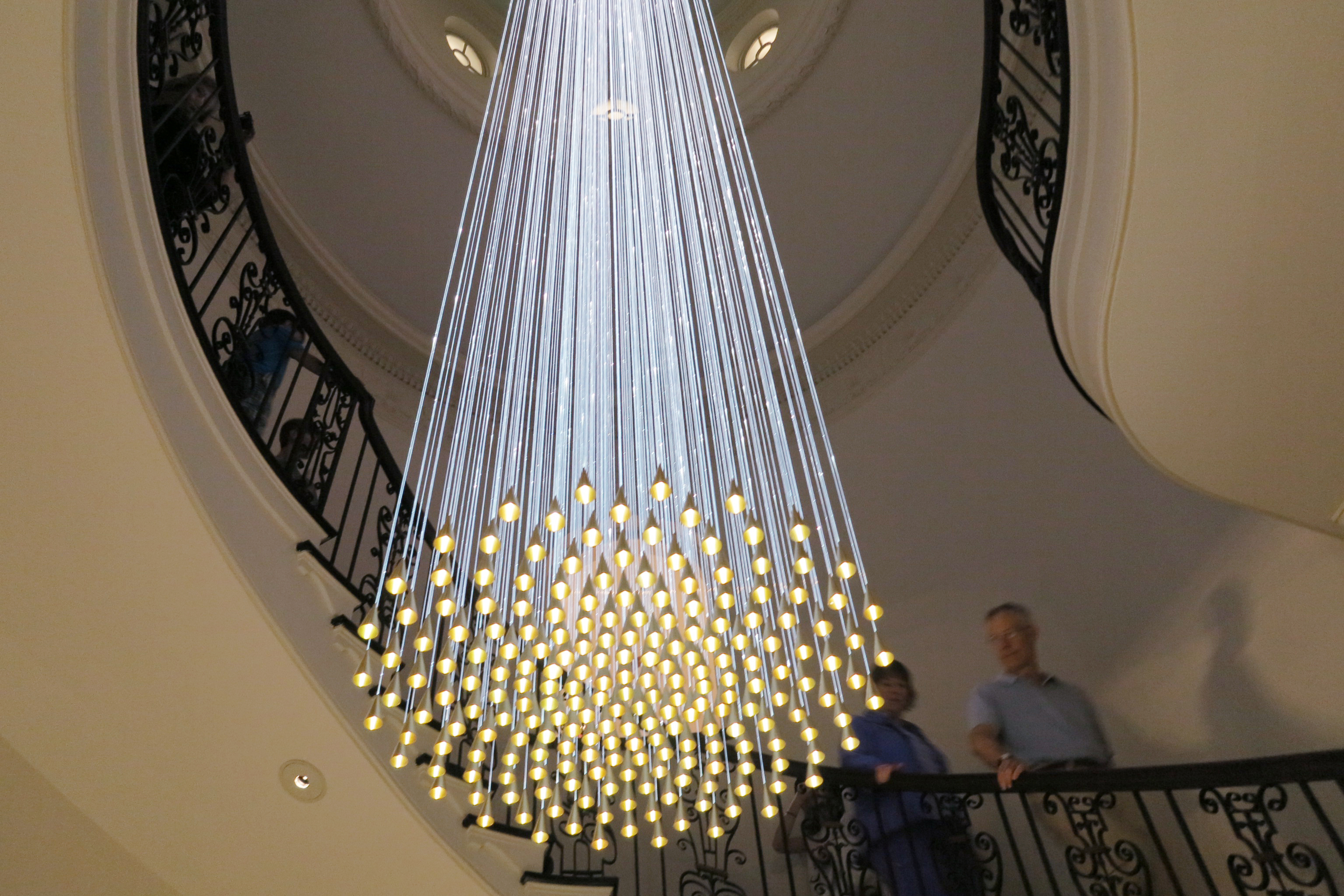
furnishings. The only thing that didn't seem to fit was a chandelier that had been gifted to the museum
by some donors. The chandelier consisted of many optical fibers hung from the ceiling a few floors above where it hung. At the end of each filament was an LED light. It had an interesting effect, but hardly fit the character of the house, built in 1929-32. The other house details were notable: intricate hardware on the doors, beautiful custom crown molding, wrought iron, limestone floors, and hand-carved oak doors.

The third floor of the house had been turned into an art gallery per the wishes of the Cheek family,
and there is also a scuplture walk on the property. I must confess that the sculpture along the woodland trail stretched my ability to understand it. One piece was a block of stone.  Another (an homage to aboriginal peoples per the description) was a bunch of dead trees
"Memorial to the Aboriginal People of this Land who lived in these Forests", or "A Bunch of Dead Trees"?
pushed into a pile. Another was a white stone bench. OK then.

After a lovely afternoon at Cheekwood, we headed over to the Parthenon, a full-scale replica of the original Parthenon in Athens. It was built in 1897 as part of the Tennessee Centennial Exhibition. Today it functions as an art museum, the centerpiece of Centennial Park, a large municipal park in Nashville. As it happened, they were
having a music festival there with performing artists. So we walked over to the venue and laid on the grass to listen for a while.

We stayed long enough to listen to one band, and then decided to try to find a place to park to cruise some of the music bars on Broadway, Nashville's lounge district downtown. Live music is the order of the day here. The bars are chock-a-block, one after the other,  on both sides of the street for 6 blocks. All have their doors open, and as you proceed down the street, you can hear snippets of each of the performers. That, combined with the thousands of people  cramming those bars and walking the street,  make quite a din. To add to the roar, there are "party barges": imagine a haywagon without the hay, full of people  who are drinking and singing along to recorded music at the top of their lungs. Then there are the pedal taverns--large wagons powered by the 10-15 people onboard who are pedaling. They were drinking as well, and singing along to music being played on their conveyance. apparently you can BYOB on those. They provide the ice and cups. The Party Barges looked like they would be fun to take with a group of people you know. Hey--BC people--want to meet in Nashville in October?

It turned out that not only were the Titans, Tennessee's NFL team, playing yesterday, but the Symphony was performing, and both institutions are within a few blocks of the downtown, making it impossible to find a single parking space. So we cruised down Broadway, and called it  a day.

Saturday, August 13, 2016

Nashville 8/13/2016

Our campground is just down the road from what we had heard is a behemoth of a hotel that is right next door to the Grand Ole Opry. We were encouraged to stop in and check it out. With 2884 rooms, and including 9 acres of indoor gardens, cascading waterfalls, and an indoor river with its own flatboats all in glass atriums, it's pretty impressive. They tout themselves as the largest non-casino hotel in the US.

We stopped in town and dropped by the Antique Archaeology store, owned by Mike Wolfe, of American Pickers fame. I think the least expensive item I saw (other than promotional merchandise) cost $300. I liked the $4800 juke box on display, though.

From there, we walked uptown to see the state house, and enjoyed an air-conditioned tour (man, the weather was steamy) with a lot of interesting history of Tennessee. We then cruised down Music Row, the area of town noted for its many music studios and publishing houses, and made an effort to find parking so we could check out the music venues on Broadway, with no luck. We'll do that tomorrow.

Photos here: https://goo.gl/photos/bdtGk8YaqPVMZ4k98

Tuesday, August 9, 2016

Nicodemus 8/9/2016

Kansas is the kind of place you enjoy on an emotional level. It doesn't stun you like the snow-capped mountains in Montana, or the Oregon coastline. But how many places are there in the east where you can see to the horizon in 360 degrees?  Rolling green hills against the blue, blue, sky as far as you can see. There's so much here, but only if you take the time to see it.

The schoolhouse at Nicodemus
Our focus today was Nicodemus, KS. Never heard of it? It is a National Historic site northwest of Salina, KS, and comprises a small part of the community that sprang up here in the late 1870s. Founded in 1877, it was the first western town built by and for black settlers. For black farmers in the region, it was the cultural and economic hub for many decades. After the Civil War, some 300 settlers recruited from Kentucky arrived here. They lived in primitive conditions--at first, in homes dug into the ground. Not all stayed here, but by the mid 1880s, Nicodemus was a prosperous town. But lasting prosperity depended on the presence of the railroad line. Despite tireless efforts of town boosters, the railroad ran several miles south of here, sending the town into a gradual and permanent decline. The National Park Service designated the entire town area a Historic Landmark in 1976, and 20 years later it was designated a national Historic Site. The buildings we saw all require serious attention to preserve them, but the history of this place is evident as you walk the streets.

Rather than return to the interstate, we opted to drive the scenic route that parallels it 15-25 miles
north. we stopped for lunch in Plainville, KS, as the sign at the town border trumpets, "Home of Jerry Moran"(?!) Jerry, it turns out, was a long time Congressman. We stopped at the Plainville Roadside Adventure Park, known elsewhere as a rest stop. We continued to Lake Wilson, and stopped to admire the gorgeous view of the landscape from the elevated vantage point. We saw a collared lizard in the parking lot!
View of Lake Wilson

From there, we traveled to Mushroom Rock State Park, an out-of-the-way attraction that has curiously shaped rocks. We traveled down a dirt road (with the RV and car in tow) to see it. There, we met a native Kansan who recommended a couple of other cool places to visit on our return.

Mushroom Rock
Beautiful country on a beautiful (but hot) day. More   photos here: https://goo.gl/photos/VezEUL5xfheoNoqS9


Saturday, August 6, 2016

Long Drive 8/6/2016

Wapiti, population 165
We were up and out earlier than usual to make the long drive to Cheyenne, WY. We ascended to Sylvan Pass through what had been a fire-ravaged area along the north shore of Yellowstone Lake. The descent was, for me, thrilling. Sitting up high in the RV, I could look straight down the embankments to the river below, views not available when riding in a car.

Further along, at lower elevations, we came to Bill Cody State Park and Dam,
Canyon walls after Bill Cody State Park
some fascinating rock formations in a canyon just after the dam, and the first sign of civilization since we left Yellowstone, a town called Wapiti. We passed through Cody, the self-proclaimed Rodeo Capitol of  the World, long stretches of treeless hills and plains, and Thermopolis, a beautiful area we visited a few years ago (http://frommyroad.blogspot.com/2014/07/thermopolis-wy-july-8-2014.html).

Once out of the mountains, our drive was mostly those treeless hills and plains, in gusty headwinds. It's hard to imagine the immense scope of this country until you've driven it.

Canyon--Lake walk 8/6/2016

Starting the trail--it's hard to capture all the flowers in the meadow
It was cold this morning: 47 degrees. Thank God for RV heat. After breakfast, we set out for the Canyon area to do a 7.6 mile hike that would take us to 3 lakes. It turned out that the lakes were nothing special, but the scenery through which we hiked was the interest-grabber. We started out
hiking up to a huge meadow covered with white and purple wildflowers with views to the mountains. From there, the trail led us into a new forest that was now growing back after fire. That led to a
geothermal area that looked like the moon--gray with minerals, smelling like sulphur, and packed with bubbling pools. From there, it was back to the forest, but this time, with a green, grassy
Lily Pad Lake
understory--so beautiful. We then returned to our starting point on a loop trail, but traversing the different ecosystems in reverse. All the while, we dodged bison scat piles, and in one place, a large pile of fairly recently deposited bear scat on the trail.

It was glorious to be in these quiet and wild places, away from the throngs of people on aa beautiful coolish (70s) day.

One issue with which we dealt was that the trail was poorly marked. Since we didn't see anyone on the trail, we had to guess in a few places, that we were going the right way, since there were few signs to direct us.

By the time we had finished this route, it was mid-afternoon, so we drove up to the Canyon north rim, and stopped along the drive to see views of the Upper and Lower Falls and canyon. Photos just don't

do the place justice. A sign of the times, seen at one of the falls viewpoints: "No drones allowed."

Friday, August 5, 2016

Fishing Bridge--Yellowstone 8/5/2016

We left West Yellowstone today  and headed for our campsite at Fishing Bridge in the center of Yellowstone. The park is so big, that it's easier to explore (with less driving) by moving to different areas of the park. The places in Yellowstone we've visited so far on this trip have been on the west side. Now we move to the center-east.

Even though the distance is relatively short (56 miles), it took 2+ hours  to travel. Like Colter Bay in Teton, our campground is for hard-sided Rvs only, no tents, pop-ups or canvas sided campers allowed. It's bear country, and the campground makes a point of telling you to practice safe food storage, and not to leave anything with an odor outside your RV.

Our site is fine, although the road to access it was probably the worst we have encountered--ever. This dirt road wasn't just bumpy, it was undulating, covered with potholes that were at least 6 to 12" deep. The road was so bad that the clasp holding our bedroom door open broke from the jostling. We traveled the road going as slow as we could but still moving forward. We had unhooked the car before we went up the road and I drove the car in 1st gear.

Once we were settled in and had lunch, we ventured out to see a bit of the area. We are close to the Yellowstone River and canyon, so we drove north to the falls, stopping at a few scenic sites along the way. But the highlight of the day came at Artist Point on South Rim Drive, that revealed one of the most beautiful views I have ever seen--Yellowstone River canyon up to the falls. This was one of those emotionally affecting moments, when you are confronted by the spiritual beauty of nature, the grandeur of what God has made. If you have never come to this particular place, please put it on your to-do list. As Americans, this belongs to all of us.
Artist Point view

As we were leaving Artist Point, we were intrigued by the name of a trail--Sublime Point. How could we resist? So we started up the trail that took us along a ridge running along the edge of the
Yellowstone Canyon. Fantastic colors in the rocks, spectacular views up and down the canyon to the
View from the Sublime Trail
river.

After dinner, near sunset, we decided to take a drive back up along the meadows along the river. We stopped at LeHardys Rapids, a lovely area on the river where the river bed drops a little bit, throwing water against the rocks and creating

white water. This is considered to be the geological boundary of Yellowstone Lake. In June and early July, you can see native Cutthroat trout leaping in the air, working their way up the river to spawn. Sometime we'll have to come back to see that.

More photos here: https://goo.gl/photos/wqgwAoKS2WKcprs58

Yellowstone day 2 8/5/2016

We spent the next day (Tuesday) checking out the geyser areas of Yellowstone with the understanding that we'd have to share the experience with LOTS of other people (I abhor crowds). But we did it anyway, because the geysers and geothermal features and rivers are really what set this park apart. The colors are
startling and not easily found elsewhere in nature. The park service has made it ridiculously easy to walk 5+ miles on the paved roads, walkways and boardwalks that provide access to all the thermal wonders. The big issue here is parking. But if you can parallel park, (Ray is the MASTER of that), then you're in better shape. We saw many places where others passed by parking spots that Ray easily parked the Elantra.

We were thoroughly amazed at Old Faithful, where throngs of people sat in the hot sun for easily 45 minutes or more waiting for the geyser to erupt. The crazy part was that there was plenty of shade only 30-50 yards away. We stopped in to the
The crowd at Old Faithful
Old Faithful Inn, a historic lodge that looks like it was built with Tinker Toys. Built in 1903-4 it is the largest log structure in the world. It's hard to believe it survived a 7.5 earthquake in 1959. It's not one of the biggest park service lodges, but it's definitely one of the most interesting.
Old Faithful Inn

Upon leaving the geyser areas, we headed back north, and took the Firehole Canyon Drive, just south of the Madison junction. The wide river funnels into the narrow canyon and creates rapids and waterfalls that were gorgeous to see. The road was all one-way, and not heavily traveled, so it was easy to take our time to enjoy the views. Until! we rounded a bend, and suddenly hundreds of cars lined the narrow road on both sides. We had been unaware that this
drive gives access to a swimming area crammed with hundreds of people. we thought we had stumbled on Blizzard Beach west. People had parked at least 1/2 mile away and walked on the road to this place. I was glad it was at the end of the road.

More photos here: https://goo.gl/photos/rWMrWMcWn3FqUzQ88

Yellowstone 8/5/2016

When we arrived at our campground in West Yellowstone the other day, we knew that we needed to get laundry done. By the time everything was clean and folded and the sheets back on the bed, it started to rain hard so we just chilled for the rest of the day.

Monday, the day dawned sunny and cool, and when we set out for the Norris section of Yellowstone, we noted that we could hardly see the mountains for the smoke. On Sunday a new fire had started west of here. That, combined with windy conditions, made for a smoke-filled park.

Norris is south of Mammoth Hot Springs on the west side of the park. One thing that strikes you immediately about Yellowstone is its sheer size. The drive from the West Yellowstone entrance to Norris took at least 30 minutes without traffic. When you look at a map of the park, you realize how small a fragment of the park that is.

Our first stop was a hiking trail to Monument Geyser Basin just south of Norris that promised geothermal features at the end. With not a lot of information about the trail, we started up. The first part was pleasant and followed the Gibbon River. Not far along, the trail headed up. And up. And more steeply--up. Switchback after switchback. The views as we ascended were great--the valley
below with the meandering river below and views of a mountain in the distance. Almost at the top of the trail, the view to the south opened up to reveal the a different section of the Gibbon River below. At this lovely spot, we sat and ate lunch. A little further along, the trail ended in a geothermal area that was alive with the sound of percolating geysers. What makes this area unique is that there are no restrictions to where you can
The view from our lunch spot
walk, and because of the difficulty of the climb, we were pretty much alone. Steam rises from scattered vents in the ground and the white billows fluctuate in intensity. Clusters of dormant geyser cones are dispersed along the white crusty ground, and some chimneys are still churning out steam. Water bubbles up in shallow pools and flows down the mountainside.

As difficult as the ascent was, the descent was all about keeping from sliding down the loose gravel trail by the pull of gravity, and saving our knees. Small steps, small steps.

We then drove over to the Norris Geyser Basin and took the trail around that area. The geothermal stuff is interesting, but I was
entranced by some grass by the side of one colorful thermal pool. It was stunning, like peacock feathers: almost iridescent--green and red and purple all at once, and moving with the wind.

More photos here: https://goo.gl/photos/miwjFdX6hozGF4JC9

Saturday, July 30, 2016

Flagg Ranch Trail 7/30/2016

Snake River from Flagg Canyon trail
We headed up to the Flagg Ranch area to lose some of the crowds, and because the mountain views further south in the valley were still obscured by smoke. The Flagg Ranch Trail description promised "spectacular views of the Snake River". While we did enjoy the trail, the "spectacular views" were few in number, and only came on the second half of the trip out. See the picture to the left.

Rather than retrace our steps on the Flagg Canyon Trail, we opted to return via the Polecat Creek Trail. The first part of that trail was not promising, as we trudged through dust and dodged horse manure along the way. Horse trail rides come through this way.  But we were rewarded big time for our efforts in the second half of that trail with views down to the creek. We sat just off the trail, ate a late lunch,  and contemplated this view:

I did say that the trail was dusty--so dusty that each footfall created clouds of dust that clung to our skin and clothes. At the end of our 7 mile hike, we took off our hiking shoes to reveal socks and feet that were absolutely caked with dust. Any exposed skin was gritty from the dust which very nicely to our sunscreen.

After dinner, we walked down by Colter Bay once more and found this scene:
Now back to the Rv for a shower. More photos here: https://goo.gl/photos/nHUKbVKi5kQRtNJbA

Tetons 7/30/2016

Because of campsite availability at Colter Bay in the Tetons, we had made reservations there, and worked that around reservations at West Yellowstone (outside Yellowstone) and Fishing Bridge inside Yellowstone. Here's the route--going north to south, then to West then east: https://goo.gl/maps/8x8LUZsqny72 The ride through Yellowstone was... interesting. The road in some places is very narrow as it goes over the mountains, and there is construction in places. At 28 feet plus 15 feet for the car, ours was not the largest vehicle combo by a long shot going over that road. But the ride is beautiful.

We arrived at Colter Bay campground in Grand Teton National Park mid-afternoon. Like most of the others, our site was not the least bit level, and it was a challenge fitting it into the site in a way that would both get it off the road, and be close enough to the utilities (water, electric and sewer) to hook up. The RV has to be level for the refrigerator to work properly. That challenge met, we chilled out for the rest of the day, and in the evening took a walk down by Jackson Lake where we saw a bald eagle perched in a tree. 

__________

Smoke obscures the Tetons
Yesterday we drove down to the Laurence D. Rockefeller Preserve, a former ranch donated to the park service (along with thousands of other acres that form Grand Teton National Park). The mountain scenery that greeted us was veiled in smoke and the smell of smoke was in the air. There are substantial fires south and southeast of here. 

At the Preserve, we took a loop trail that took us by lovely Phelps Lake. The Preserve has a wonderful and unusual visitor center. While most visitor centers give you lots of historical, ecological and geological info, all this center tries to do is to get you in a frame of mind to experience the beauty of the preserve itself. There is little reading, but lots to engage your senses. The first room you enter has high definition nature videos. Later you encounter a soundscape room with nature recordings from the Preserve. All you are asked to do is look and listen. There is a reading room as well, filled with books about the area and nature, and fitted with comfortable chairs in a room with views to the mountains. Gorgeous.

Outside view of  Episcopal Chapel

View behind the altar of Episcopal chapel
On our drive back we stopped at the Church of the Transfiguration, an historic Episcopal chapel  with a view behind the altar to the Teton peaks, and the Chapel of the Sacred Heart, a Catholic Chapel with the same designation. As you can see from the pictures--pretty inspiring, huh?


Thursday, July 28, 2016

Two Medicine 7/28/2016

The view from the edge of the lake at Two Medicine
The day after our visit to Iceberg Lake, we headed down to the southern parcel of Glacier at Two Medicine. Because it is a bit more distant, and not connected to the Going to the Sun road, fewer people typically visit this area. That makes it more attractive as far as we're concerned. The drive out to Two Medicine was, as usual, gorgeous. On the way, we stopped to note that the forest that had burned many years ago was now covered with new growth of trees--nature renewing itself.
New trees growing after fire


The hike we chose at Two Medicine was a short one (4 miles round trip), and the elevation gain was minimal compared to many others in the park, about 650 feet. What we found out was that all the elevation gain was at the last 1/2 mile, making that portion pretty steep. I must say I sweated my way through that last half mile. On the return, dark clouds were gathering, and we could hear rumbling thunder. But we witnessed just a few sprinkles.
We saw a moose off the trail in the water. After our hike, we drove over to the East Glacier hotel,  where the road in to the hotel was covered with gravel, a result of the storm that we had missed. Apparently the downpour there was heavy, and there were large puddles everywhere. On our return to St. Mary, we saw a few piles of accumulated hail along the side of the road. Such is the hit and miss nature of weather in the mountains, I guess.

One thing we have dealt with on this trip that we never had to before is bugs. In Michigan and Minnesota, I managed to pick up at least 15-20 mosquito bites on my legs. Here at Glacier, the hike to Iceberg was plagued by flies and bees. At Two Medicine, I was bitten several times (5-6) right through my compression sleeve (I think those bites might be from deer flies.), and got several more on my legs.  Oddly, Ray has no bites. He's usually the one to get bitten.
_________

Wheat and canola fields
Yesterday was a travel day--going from St. Mary area of Glacier down to Livingston, where we would stay one night before heading to Colter Bay at Grand Teton National Park.  We took the less traveled route down Route 89 rather than the Interstate, and enjoyed the ride. We traveled through lots of farmland, and loved the visual contrast between the wheat fields (tan colored--amber waves of
grain!) and the canola fields (bright yellow). Our campground is on the Yellowstone River about 50 miles north of Yellowstone National Park. We woke this morning to the bellowing of moose nearby (https://www.youtube.com/watch?v=--PyKhohVcY).

Tuesday, July 26, 2016

Iceberg Lake 7/26/2016

We had never visited Glacier NP at this particular point in the summer season. Our forays here were always in the very beginning of July. One time here, we arrived a day after the Going to the Sun Road was opened. As a result, our hikes to Iceberg Lake (actually 10 miles roundtrip, we discovered) were always taken at the height of wildflower bloom time for the lower part of the hike.

So when we started out on the trail, we were somewhat surprised to see that while there were some wildflowers, there were not the eye-popping drifts of flowers we had witnessed previously. But, of course, the mountains never disappoint, and the views from the trail were, as ever, spectacular. What
Meadow near the lake. Photos can't capture how stunning it was.

we found out, though, was that the second half of the trail (past Ptarmigan Falls) which was never, for us, a wildflower standout, was, at this point in the season, crazy with flowers. As a matter of fact, the last part of the trail approaching Iceberg Lake had in past years been covered with snow. I have pictures of us walking on snow so deep we could touch the treetops. Not this year. Reds and yellows interspersed with drifts of white and purple were everywhere in the meadows in this part of the trail. This trail never disappoints.

When we got back to the RV, later in the afternoon, we relaxed for a bit with a beer or 2, then decided to treat ourselves to dinner at Johnson's restaurant. We brought back to the RV some Huckleberry Ice Cream pie for dessert--a satisfying end to a great day.

Iceberg Lake as you approach from the trail. Usually there is a much larger iceberg in the lake that persists. This year it was VERY small.