Thoughts Become Things

Wednesday, October 30, 2013

Snow in October 10/30/2013

Carlsbad, NM was our ultimate destination today, by way of White Sands National Monument. We pulled into White Sands with no real expectations for what we'd find here. What a delight! Great wave-like dunes of gypsum sand have engulfed 275 square miles of desert, creating the world's largest gypsum dunefield. I knew it would be something different when I looked at Google maps satellite picture of the place.

The ride there had us climbing the mountains and then going back down. We had a great view of the terrible smog that sits over that area. On our approach on Route 70, Border Patrol was checking all cars--ostensibly for citizenship. We were asked if we were citizens, and then allowed to continue.

White Sands is a stunning landscape of glistening white dunes. We took a few short hikes onto and around the dunes. Fall foliage on cottonwood trees and rabbitbush stood out on the stark white sands. Wind whipped the sand around and at us, creating ripples in the sand that made the scene look like a fabulous artwork. At one point on the trail, we saw what appeared to be a bush at the top of a dune. The sign there explained that we actually were standing at the crown of a cottonwood tree that was buried in a dune. As long as some leaves stay above the surface of the dune, the tree can survive. The road that runs the length of the Monument is part paved, part ... sand. When we reached the sand part, we both had the same reaction: we were driving on white sand that looked so much like snow! And we subsequently saw a grader that was grooming the road because it is constantly being covered by the wind with more sand. That grader looked way too much like a snow plow.
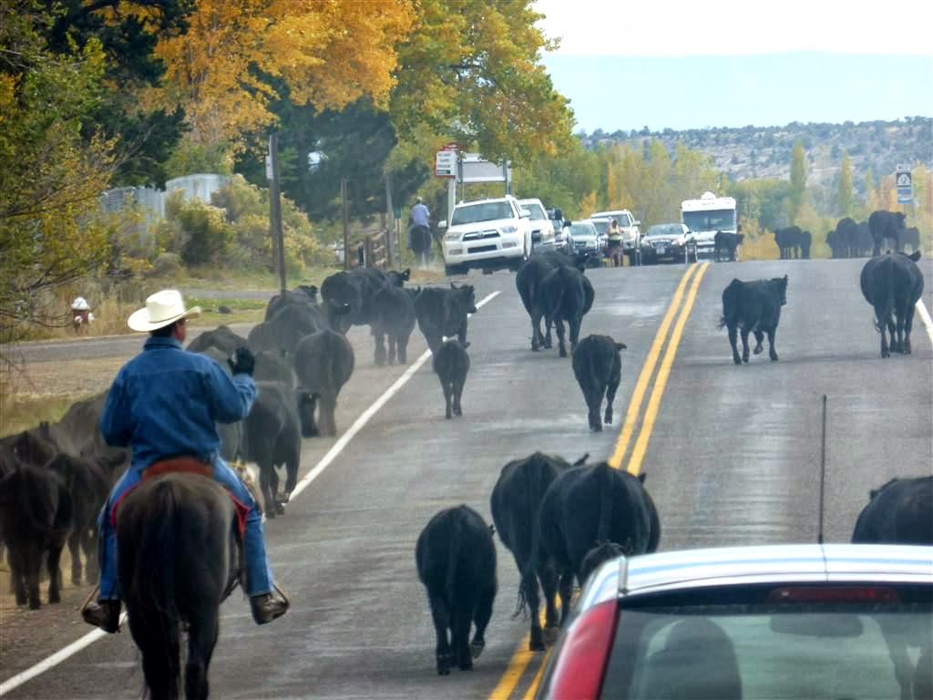
The view from the truck. It's NM in October not NH in December!
Such a beautiful and odd place!


The trip from Almogordo to Artesia, NM, where we were staying for the next 2 nights was fascinating. We traveled through such varied landscapes: mountainous to rolling hills decorated with golden cottonwood trees to flat desert open to the horizon. We drove through Hope, NM, a very small town studded with abandoned buildings, a store with a faded sign advertising homemade burritos, and a park designated by a sign and 3 picnic tables under shade shelters. We passed cotton fields, and oil derricks, and a natural gas field.

The KOA at which we are staying is large, clean, and the proprietors are very friendly. Tomorrow: Carlsbad Caverns!


Wind! 10/29/2013

As soon as we headed south towards Tucson, we felt the winds increase. Soon the winds were whipping, and dust was blowing across the desert through which we were driving. The dust was so thick that the distant mountains were obscured. Ray was white-knuckling the steering wheel, as we could feel the truck and trailer rock behind us. This lasted for about 70 miles from Casa Grande to Tucson. Ray did a great job getting us through this stretch. We found out after the fact, that a 19 vehicle pileup occurred on this stretch of road about an hour and a half after we passed through. Timing is everything.

The 400 miles we drove took us past walnut and pecan tree groves, several very long freight trains (100+ cars in some instances), the Continental Divide, many dust storm warning signs, one mountainous area, and several "South of the Border" wannabes. If you've ever driven south on the east coast down I95, you've seen the many billboards along the highway in North Carolina inviting you to stop in. New Mexico has ,"The Thing", "Butterfield Station", and "Continental Divide"(the roadside stop).

We passed a sign for the town of Truth or Consequences, NM, which prompted me to look up the origins of its name. Truly American.

We spent the night in a KOA in Las Cruces, NM--clean, convenient and quiet.

Monday, October 28, 2013

Taking a Break: October 27th and 28th-2013

As we usually do, we took our time packing up and set off for Scottsdale, AZ, where we will visit for a day or so with family. We were surprised at the amount of traffic we encountered as we approached the northern limits of metro Phoenix. Our trip took up through some dramatic desert scenery, and featured a major change in temperature. While the day started in the 30s, by the time we reached Scottsdale, temps were in the warm 80s. Thankfully, we had prepared by wearing t-shirts, shorts and sandals.

We will head towards New Mexico tomorrow.

Exploring Grand Canyon--October 26, 2013

Last night, temps were predicted to go down into the twenties (a 40 degree drop from daytime highs), so Ray unhooked the water hose for the night.  After filling water bottles, packing lunch and snacks, and slathering on sunscreen, we headed toward South Kaibab trail. The trail descends 1000 feet from the rim to the point we determined would be a turnaround spot, Cedar Ridge. As we set out on the trail, I made a promise to myself not to take any photos on the way down. I figured that photo breaks on the way back up would probably be appreciated.


If you enlarge this photo, you can see hikers on the trail up in switchbacks along the hill ahead.
At a breezy Ooh-Aah Point


The trail down was dusty, but as expected, spectacular. One spot on the trailhead been aptly named Ooh-Aah Point, a place on the trail that offered a 270 degree view of the canyon. Wow. We had to carefully watch our steps to avoid rocks and also mule droppings.

As we descended, in the back of my mind, I somewhat dreaded the ascending return. As the Ranger had told us: "Going down is optional, going up is mandatory." But the return from Cedar Ridge was not bad. The fact that temps were in the high 50s really helped. We were amused, amazed, and confounded to see several parents carrying babies and /or toddlers down the trail. We wondered how far would they really go before they realized they had to carry or drag their kids back up.

On our return to the rim from the trail, we set off for a different section of the rim trail, a bit west of where we had walked yesterday. To get to the trailhead we made use of the park buses. What a convenience! They allow you to be dropped off at one point of the rim trail and picked up a few miles down the road. (The shuttle system here at Grand Canyon allowed us to avoid using the truck and all here.) That part of the rim trail was gravel and took us close to the edge of some steep precipices. By the time we took our last steps on the trail,  the sun was casting golden light over the canyon making for an awesome finish to our hike.

By the time we got back to the trailer, it was almost sundown. Before we had left this morning, I'd made beef stew in the crock pot. So dinner was just about done when we returned. Let noone think we are roughing it, in the least. One last treat at Grand Canyon after dinner: another glimpse of the Milky Way.

Saturday, October 26, 2013

Truly grand--October 25, 2013

Our expectation was that it would take about 3 1/4 hours to get from Page to Grand Canyon Village. We were pleasantly surprised to find ourselves at the entrance station to the Grand Canyon within 2 hours and 10 minutes. What we hadn't taken into account was that it would, in fact, take another hour to actually get to our campsite in the Grand Canyon Trailer Village. We had forgotten how huge this park is. Luckily, there was not much traffic.

Our campsite has full hookups, meaning it has water, sewer, and electric. (What? No cable???) For a National Park campsite, though, it really is luxurious. Another bonus is that it is within an easy walk to the canyon rim. After setting up, we took a short (about a mile) walk on a paved path to the Visitor Center. Temps were in the high 50s, low 60s, and very comfortable. From the Visitor Center, we walked about 2 miles along the Rim Trail, which, as the name suggests follows the South rim of the canyon. Expansive views of the canyon spread before us every step of the way.

A big difference now, from previous times we have been here, is that for most of the year, you cannot drive the main park road that goes out to Hermit"s Rest at the westernmost point of the South Rim. The park service runs natural gas powered buses on a 15 minute schedule. So we were able to walk along the rim, and then take the shuttle back to the campground.

One big surprise was that there is cell service and 3G (thank you, Verizon) here. Because the nightly temperatures fall into the 20s, we unhooked our water line for the night. It would not be nice to wake up to a burst water hose.

After dinner, we went out for a short walk away from the lights, and got the best show of the day: in the cold, clear, dry night, the Milky Way spread out in the sky before us. Spectacular!!

Thursday, October 24, 2013

OMG! Antelope Canyon 10/24/2013

We were able to get a reservation for the 9:30 tour of Antelope Canyon, so we took it. Antelope canyon is a slot canyon near Page Arizona. It is located on Navajo land, and so access is via a tour offered by Navajo concessioners. We arrived early to check in, and thankfully so, because we discovered that we had come to the wrong concessioner. Our transportation to the canyon was an open air conveyance, something like picnic table benches attached to the back of a pickup truck, where you sit facing out. The ride on the pavement wasn't bad, but once we hit the sandy river bed, things got much bumpier. When we departed, it was about 45 degrees, and cloudy, making for a chilly ride.

But OMG!! We have traveled all over, and never seen anything like this. Our guide, Ardin (not sure of the spelling), was wonderful. He explained that originally the canyon was open to the public, but the Navajos would have to regularly go out and clean up trash and graffiti. So they made access only through these tours to preserve this wonder.


There were ten people in our group, and Ardin walked us through the canyon pointing out places where a particularly effective photo shot could be taken, and explaining why certain twists of rock looked the way they did.
It was amazing to hear that flash floods carry silt from the dry river bed we drove in on, and fill the canyon up, many places by up to 10 feet in depth from one flood. That same silt may be Water has sculpted the rock into fantastic twists, turns, and corkscrews, with swirls and patterns that are enhanced by the shadowy light that filters in from up above. To walk through Antelope Canyon is to walk through a miraculous art gallery.

After our trek out to Antelope Canyon, we returned to the trailer for lunch. We set out for Glen Canyon Recreation area, where we checked out the lodge and marina. A large party boat was being removed from the lake (Powell), and towed away by a tractor that was dwarfed by the enormous boat. I walked out onto the bridge that spans the Colorado River and got some great shots. Vertigo got the better of Ray when a few large tractor trailers came whizzing by and caused movement of the bridge.

Then it was time for more mundane pursuits, i.e. laundry.

A sleeping horse and a horseshoe 10/24/2013


Our destination today was Page, Arizona, located in northeastern Arizona, about a three hour drive from Cannonville (our camping spot for the last 3 nights). We drove south on route 89, which took us through some interesting country. We traveled through small towns, desert and fantastic scenery. We saw a horse completely prone on the ground in his corral, and learned that this is not unusual for horses. We passed a gas station with the highest price we've seen yet for unleaded gas $4.349 per gallon. And we passed through Red Rock Canyon-- beautiful. Shortly after we crossed the Utah-Arizona border, we arrived at Glen Canyon Dam. Construction of this dam was started in 1956. It regulates the flow of water in the Colorado River and created LakePowell behind it.

We stopped at the visitor center and took the tour into and onto the dam. The young lady who led the tour did a superb job explaining both the history and function of the dam. We learned that the town of Page was created to house workers constructing the dam. Prior to the dam construction, the area was wilderness. Its 17 square mile site was obtained from the Navajo tribe in exchange for other land they wanted. Great tour from the top of the dam down to the generator room.

After the tour, we decided to check in at our campground. It turned out to be a great deal. It's clean, quiet, and the site is level. We ate lunch, and then took off to check out Horseshoe Bend, a horseshoe-shaped meander of the Colorado River just a few miles south of Page.

From the parking area off Route 89, we followed the sandy trail down to the lookout point that stands
1000 feet above the river. So beautiful!

Our next stop was one of utility. Low on groceries, we shopped at the local Safeway, then returned to the trailer where we relaxed outside with a glass of wine. A trailer pulled in and set up a few sites away from ours, and the travelers then set their chairs up for evening beverages as well. While I set off to snap a few pictures of the gorgeous sunset, Ray engaged the newly arrived couple in conversation. It turns out that one of the woman's sisters went to BC, one to Regis, and she had gone to Boston State (Ray and  I both took classes at Boston State). Small world!

Tuesday, October 22, 2013

Bryce. I mean, Bryce!! 10/22/2013

This day was all about the views: from the top of the Bryce plateau down to the forested next level and back. This is an amazing and grand place. Pictures tell the story.


Monday, October 21, 2013

Kodachrome 10/21/2013

Our first stop today was Grosvenor Arch, a double arch located in Grand Staircase Escalante. To get there, we had to drive down Road 400, what they call an "unimproved road". Driving down this rutted gravel road, we rounded a curve, only to be greeted by a steer by the side of the road. OK... A little further on, we saw a speed sign for 35 mph (really??), and immediately after, the road dipped severely and we plunged into a deep pool of water. Glad we had 4WD. The arch itself is impressive, especially when framed by a gorgeous bluer than blue sky.

After investigating the area around the arch, we headed to Kodachrome Basin State Park. In 1949, members of a National Geographic expedition named the park for its spectacular colors. Geologists believe the landscape here was once similar to Yellowstone National Park, with hot springs and geysers which eventually filled with sediment and solidified. Over time, the sandstone surrounding the geysers eroded, leaving large stone spires.

We started our exploration with a hike on a loop trail that took us atop a ridge that provided phenomenal
views of the area. Our next foray took us on a trail across desert terrain covered with sagebrush and low trees. We passed several tall spires, a cave whose walls were marked with handprints (not sure if they were
left by cowboys or Indians), and a "Secret Passage", a part of the trail through a narrow canyon.

Lastly, we took a loop trail around Shakespeare Arch. All told, we figure we hiked about 7 miles all together on all trails. Such fantastic country---and it's all ours.
We were thrilled to have such comfortable hiking weather, (50s and clear), and to be able to experience all this without any company on the trails. It was blissfully quiet.

This was all topped off by the sight of the last building we saw before our return to the campground. Gotta love this country.

Sunday, October 20, 2013

Grand Junction to Bryce 10/20/2013

We decided to take the scenic route south to Bryce Canyon, and as Robert Frost said, "that has made all the difference". For the most part, I70 out of Grand Junction was unremarkable--flat desert country. And truth be told, I know that I fell asleep for parts of the drive. But after we left I70 for Route 24 going south, things changed. We started to see lone rock formations by the sides of the road. By the time the road spiked west on Route 12, we were entering red rock country.

Route 12 is a scenic byway that runs through small towns and spectacular scenery that includes Capitol Reef National Park. This place is filled with cliffs, canyons, domes and bridges, much of which is visible from the road that traverses it. Golden-leaved autumn trees that grow along the river framed views of the red and white rock cliffs in the distance.

Further along Route 12, we entered the Grand Staircase Escalante National Monument. This is a place that spans nearly 1.9 million acres. As we ascended the hills, the views became more expansive, and I found myself saying to Ray: "Wow! That's gorgeous!----- Don't look!", as we rounded narrow curves on the road. We arrived at the top of a mountain, and were greeted by a fabulous 360 degree panorama of some of the wildest, most beautiful land in America. So big. So grand.

After the ride up the mountains, came the ride down--at a 14% grade. I don't think we had ever before seen a road with a 14% grade. One highlight of the trip came when we found ourselves behind a herd of cattle on (not by the side of) the road near Boulder, UT.

We arrived at our stopping point for the next few days at Cannonville, UT, not far from Bryce Canyon National Park.

Colorado National Monument 10/20/2013

Our travels today would take us to the Colorado National Monument, part of the National Park Service near Grand Junction in west central Colorado. Spectacular canyons and rock formations are the feature attractions.

It was a gorgeous day today, with weather perfect for hiking--bright blue skies, temps in the 50s. The park has many trails, of which we hiked several from the canyon rim. On all of them, the views were amazing: huge rock columns (with names like Kissing Couple and Coke Ovens) and formations flanking valleys, with mountains in the distance fronted by the city of Grand Junction.


The best surprise of the day was the last hike we took. The trail is called Devils Kitchen, and is described as a room of rocks. The trail was easily walked, and the last part took us up a steep, rocky incline. As we reached the top, and followed the rock cairns around the bend, we felt as though we were crossing the threshold of a giant rock edifice. Huge boulders surrounded us, with a window formed of rocks at the far end. It's hard to describe the cool factor of the moment, but it really was awesome.

By 6:00 we were back at the trailer, relaxing with a glass of wine (me), and a beer (Ray). What a great day!

Saturday, October 19, 2013

Snow 10/19/2013

We woke up early with the intention of making our one last great push west,  and ending our day in Grand Junction, in western Colorado, about 560 miles away. Imagine our surprise to lift the shades and see everything outside coated in a blanket of wet snow. The temperature outside was a balmy 34 degrees. And it was still snowing.

We ate breakfast, showered, packed up, and pushed off. In our haste, we inadvertently left behind one of our wheel chocks. Oh well.

The first part of the drive took us through a bit more snow, some fog, then mist and clouds. Gradually, the weather cleared. Western Kansas and the eastern third of Colorado are flat and featureless, with farms lining the interstate on both sides. The snow persisted on the ground from the campground all the way to the western side of the mountains.

Once in the mountains, the scenery was spectacular. We saw snow-capped peaks behind golden aspens. And we passed through Glenwood Canyon, where rock walls soar 1300 feet above the Colorado River for 12 1/2 miles. The going was slow pulling the trailer up the mountains.

By the time we had arrived at Grand Junction, the skies were clear, and the temps had warmed to the high 50s.

Thursday, October 17, 2013

Konza 10/17/2013


Bright blue skies greeted us this morning as we set out for Konza Prairie Preserve just south of Manhattan, Kansas, and within about an hour's drive of the campground. The landscape is definitely flattening out. We were surprised that there were no signs directing us to the preserve, and it had no recognizable address on the GPS. We just followed the directions posted online.

The Konza Prairie is an 8600 acre tract of native tall grass prairie that has never seen a plow. Big blue stem grass, 1 of the grass species here, can grow up to 10 feet tall, with a root system that can reach 12 feet into the soil. Can you imagine being a settler here, trying to farm, with the need to first dig out the sod? Amazing.

We set out on the easy 6 + mile walk after eating lunch in the trailer. While the breeze was cool, we soon found ourselves shedding our jackets and enjoying the perfectly comfortable day. The trail took us up to a small ridge with views of the hills and plains. Tall grass dotted with stands of bright red bushes (that we
thought might be sumac) stretched before us. The deep blue sky, gold, yellow and green trees, and red bushes on gently rolling hills made for a beautiful sight as we walked alone on the trail. While we saw a a few cars in the parking lot (which surprised us that there were any, due to its somewhat remote location) we saw noone on the trail. However, we were not completely alone.

With every step we took, it was is if we were at the rear of a grasshopper parade. Our feet disturbed the grasshoppers who flew in every direction before us. When the wind was blowing, there were so many grasshoppers, it was not unusual to have them blow into your hands, face or body. When the wind calmed, all you could hear were crickets and the snapping of grasshoppers as they moved around us.

Konza Prairie gave us the opportunity to see Kansas exactly as it looked 200 years ago.

After our walk, we headed west to our stopping point for the evening, Wakeeney, Kansas. We passed fields of sorghum (think the stumpy corn with a plume on top), wind farms (congregations of wind mills), and several abandoned farm houses in the fields along the interstate. Sometimes we'd see an exit off the highway for a town that must exist somewhere beyond the horizon, as all you could see on either side of the highway was a dirt road going across flat land and fields. One startling sight: thousands of starlings roosting covering the roof of a building.

Most people consider the Midwest as flyover or drive-through country. How wrong they are. It's a quiet wonder waiting to be discovered.

Wednesday, October 16, 2013

The "Little Smokies" 10/16/2013

We left our campsite this morning with the idea that we would take the scenic route west from eastern Indiana toward Illinois, through Missouri to Kansas. We knew it would be a long day of driving. We both expected to see farms and flatland. Boy, were we surprised. Route 46 out of Columbus took us over beautiful rolling hills lined with trees showing bright fall colors. The day revealed other interesting surprises.

We have previously seen only one story ranch houses on our travels in Indiana. Today we saw many multi-story houses set on gorgeous hills. Our drive took us through a lovely area dubbed "The Little Smokies", not only for the mist that rises from the hills, but also for the beauty of the area. Route 46 took us past Nashville, Indiana, a mecca for artists, and a motel called "Always Inn". Love it. I was so excited when I spied a bald eagle soaring not so far above us as we drove not far from Bloomington.

Illinois and Missouri were a blur of Highway and flatland. It was surprising to realize how far  St Louis spreads out on I70. We made it into Kansas by about 5 o'clock local time (1 hour time change). By the time we realized that we needed to get gas (again), we were in Kansas boonyland, and had to take a small jog off the interstate to find a gas station. We arrived in our nightly resting place, a KOA in Topeka, by 6:30. We're getting much quicker at setting up and breaking down the trailer.

Tuesday, October 15, 2013

Columbus...Indiana 10/15/2013

We normally shower in the trailer in the morning, but Ray had mentioned last night  that he had stopped in the rest rooms and that they were "amazing". How could I not check them out? Wow. These were not your run of the mill campground restrooms. Impeccably clean. New tile. Huge showers. Sensor commodes, water faucets, soap and towel dispensers. And a TV. So this morning I luxuriated in a shower that was almost the size of the living room in our first apartment.

After packing up, we set off toward Columbus, IN. (The ride was highlighted by long stretches of highway shrouded in dense fog. Needless to say, visibility wasn't the greatest.) This small city of about 45,000, located about 40 miles south of Indianapolis, is the home of Cummins, Inc., and over 70 architectural gems. Irwin Miller, instrumental in building Cummins into an industrial giant, became the driving force in building Columbus into a center of design excellence, and home to buildings designed by the likes of IM Pei and other renowned architects.

Our first stop was the visitors center, where the highlight was a gorgeous internally lit chandelier designed by Dale Chihuly.

From there, we strolled the streets of Columbus, checking out many of the fascinating buildings lining its tree-lined streets. We visited the gardens of The Inn at Irwin Gardens, now a B+B, built in 1864 by the Irwin family, which has been impeccably maintained with much of the original ornamentation and furnishings intact.

One memorable stop was at a veterans' memorial,
on whose pillars were engraved not just the names of Columbus veterans who had perished in wars, but also snippets of letters they had written to their loved ones back in Indiana while they were still at war. Very moving.

Once finished with our tour, we headed for Walmart, to pick up a few things, and then back to camp.

Monday, October 14, 2013

Construction forever 10/14/2013

After a comfortable night, we got up, had breakfast, and set out for a spot just east of our destination tomorrow, Columbus, IN. That would give us about 9 hours of driving for the day. We have to stop every 200 miles or so for gas, with the cost per gallon at about $3.highway7 per gallon. The day started partly cloudy, progressed to misty and foggy and ended clear and sunny. Along the way, we drove through the beautiful hills of Pennsylvania that were painted with the gorgeous colors of fall. Those hills reminded us of West Virginia, although they weren't quite as dramatic.

Thankfully, there was no drama today. At one point, we came upon a detour on I84 for an accident. There were several electronic signs along the way telling us to exit from the highway at a certain exit. But when the time came to exit, there were no barriers in the road, and we just continued on the highway with the rest of the traffic.

One thing that struck us was that there was construction on I76 from just outside Akron to just outside of Columbus, Ohio, for about 80-90 miles. What struck us is that in NH, they are widening route 93, and it seems to be taking forever to complete sections that are just a few miles long. Ray just LOVES driving for long stretches between narrow concrete barriers.

By the time we arrived at the KOA in Brookville, just a few miles west of Dayton, we had blue skies. Tomorrow, we will head to Columbus, IN, about 2 hours away.

Addendum: OMG-- the bathrooms at this place are gorgeous and impeccably clean. They rival those at really nice hotels. I thought Ray was nuts when he came back from the bathroom last night, raving about them. Now I know what he meant. All other KOAs will have a hard time coming up to this standard.

Sunday, October 13, 2013

Losing air. Literally. Losing air. 10/13/2013

After rising early and finishing packing the trailer, we managed to get on our way by 9:12 a.m.  We had originally hoped to make it to Mercer, PA, in western  PA. All was going great until Ray noticed that the warning light for low tire pressure was lit. As soon as we were able, we pulled into the nearest rest area, and checked the tires. Uh-oh. The driver's side front tire was low. We filled the tire and moved on. 100 miles later, the light flashed again. Uh-oh. Time to look for a place to check the tire out. We found a Walmart close by, and decided to stop there. When we bought the truck, we saw that the front driver's side tire had a nick in the sidewall. We were assured that it was OK. Having driven it around for 9+ months, we never thought that it was a problem. Until today. There was a slow leak right at that spot. So, we instructed them to put the spare on. The original tire was unfixable. But after talking about it, Ray and I decided to get a new tire mounted on the original rim, putting the spare back.

The cost of the new tire was $200 installed. OK, let"s get this show on the road... Except that the guy installing the tire damaged the tire sensor while putting the tire on, so the warning light will always stay on. He offered to give us the tire gratis, and we will have to get the sensor fixed. If the sensor fix is more than $200, Walmart will hear from us.

Needless to say, we didn't make it to Mercer. We stopped at the Williamsport, PA KOA, where we are comfortably ensconced for the night. We'll just have to make up the 3 hours tomorrow.

Saturday, October 12, 2013

A new adventure 10/12/2013

After beautiful interment services for my Mom and Dad this week, and a great time with my brothers and sister, Ray and I are ready to embark on a new adventure. For the next 4 weeks, we will be traveling around the US, and enjoying the comfort of our home away from home. We expect to visit some very cool places, even without the cooperation of the federal government, if need be, among them: Columbus, IN, (National Geographic Traveler magazine ranked Columbus 11th on its list of historic destinations) Konza Prairie, Antelope Canyon, Grand Staircase Escalante, Grand Canyon, and much more. Please join us!