Thoughts Become Things

Saturday, October 30, 2021

A visit to the tire store


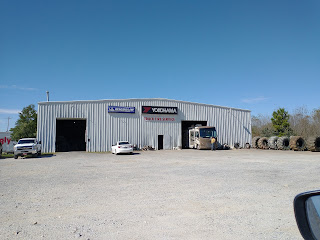
Our original plans for the day were to take a couple of hikes a little further south down at Little River Canyon. But those plans were disturbed early in the day, after Ray went out to add air to one of the tires that looked low. We have a TPMS (tire pressure monitoring system) that reports on pressure and temperature of each of the 6 tires on the RV. I was inside when I heard Ray yelling that the tire was losing air. In using the tire inflator, the valve stem of that tire popped out, and air was hissing out of the tire. Ray was able to finally cap it, but not before the tire had lost a lot of pressure. Our only option now, was to find a tire shop and get the stem repaired. We were leaving for home the next day, and couldn't ride long-term on that tire without the danger of a blowout. Fortunately, it was early in the day, and we were only 20 minutes from a nearby town that did have a place that could help. So, we packed everything up, pulled in the slides, and drove down to Fort Payne (very carefully) to get the tire stem fixed. The people at the tire shop were very accommodating and helpful, and took us right away. About 20 minutes later, we were on our way back to the campground to re-set up, and get on with our day.


By now, it was afternoon, and we headed south to Little River Canyon. We took a hike along the river to a beautiful spot with a smaller falls (than Little River Falls a bit further north). During the summer, this area is a popular swimming place (called the Hippie Hole). Fortunately for us, since it was the middle of the week in fall, we mostly had the area to ourselves. It's a rocky area that defines a large pool just beyond the falls. The trail down is rocky and root-y, and the last little bit is a rock staircase of 160 (someone else counted them) steep steps. Nice trail, beautiful spot.

We then decided to drive the road along the canyon. It doesn't have lots of views, but the road itself is a hoot. Continuous ups and downs, around hairpin curves. There are warning signs at the road's entry points that the road is impassable to trucks, trailers and RVs. With the Elantra, it was just a matter of continuously managing the stick shift. 

Tomorrow begins the drive home.

Photos here: 
https://photos.app.goo.gl/85hdof5Pvkqsdhz29

Wednesday, October 27, 2021

Woods walk and Falls Bottom


Yesterday morning we set out to a local trail that wound through the woods. Unlike NH forests, this one had little to no shrubby understory. Instead, the forest floor was often covered in haircap moss, sometimes interspersed with deer moss. With the falling leaves, it gave the forest an open feel. We crossed 2 creeks and also passed by an old homestead, now being subsumed by the forest. The day was cool, in the 50s, even with the sun that eventually came out, so it was a jeans day for us. The trail wasn't particularly well marked, and it was fortunate for us that we had our AllTrails app to let us know we were headed in the right direction. The trail was always thickly covered in leaves, and it didn't look like it had been heavily used as the leaves had not been walked on. The were no trail blazes except at trail junctions.  As a matter of fact, we were the only people there. When we left, and when we returned hours later, ours was the only car in the trailhead parking lot.

In the afternoon, we headed back over to DeSoto Falls, and took the base of the falls trail. Very steep, and very rocky, it was pretty interesting. It took us by some towering rocks and a rock cave. The view at the bottom allowed us to see the bottom cascade of the falls in its entirety. 

Great day.

Photos here: https://photos.app.goo.gl/JFZm82FQ1XY3GjuH8

Tuesday, October 26, 2021

Falls and a rock in a chapel

We are currently in northeast Alabama at DeSoto State Park. We started the day at DeSoto Falls. From the sign there: "In 1925, A. A. Miller, an electrical engineer, built the first hydroelectric dam in North Alabama above DeSoto Falls. He built the dam to help supply power for his hydroelectric generator which he constructed below the falls. At first Fort Payne was furnished with electricity from dark until midnight. Then after a number of local women had purchased


electric irons, power was supplied on Thursday afternoons to enable ladies to iron. Later electricity was made available all day and night. As there was no central switch for the street lights, Ernest Wallis, a young schoolboy, became Fort Payne's equivalent of the "Old Lamp Lighter", riding his bicycle up and down the streets at dusk to turn the lights on and returning after dawn to turn them off."

After the dam, there are two tiers of falls that drop 107 feet, the tallest in Alabama. The risers of the stairs that lead down to the falls are decorated in mosaic tile. The base design is of the West Fork of Little River formed from blue pieces of glass, and the extra spaces were decorated by residents and park visitors. A quote by John Muir flows down several steps and reads, “Everybody needs beauty as


well as bread, places to play in and pray in, where nature may heal and give strength to body and soul.” The art was a delightful surprise, as you can't see the decoration going down the steps.

On our way to the falls, I noted a chapel at the side of the road we were traveling, and we determined that we would return after our trip to the falls. What had caught my eye was a giant rock protruding from the building. When we finally made our way back, we found that while there was no one there, the


church was open. It was the Sally Howard Memorial Chapel, built in 1937 by Milton Howard in memory of his first wife. The church still holds Baptist services. The building is, indeed, built around a giant boulder, and made of stones from the Little River. The boulder sits behind the lectern in the church. It was a sweet, peaceful place.

We then returned to the RV and set out on a short hike. The weather has been cooperating, for the most part. It rained this morning, but by mid-afternoon, the skies were clearing, and temps were in the low to mid 60s. 

More photos here: https://photos.app.goo.gl/wQsQWQ7AJ6uKBHh67


Sunday, October 24, 2021

Gravel Road and Split Bow Arch

Cumberland River Overlook
There was another interesting trail at the small nature preserve we visited the other day that we thought we'd explore yesterday. We enjoyed the hike we took so much and the fact that this little out-of the-way place was completely deserted. When we arrived at the trailhead we were surprised to see 20 cars jammed into the tiny parking lot. And another car arrived just as we pulled into the lot. We opted to find another adventure. 

Big South Fork is bounded by two roads; a gravel road on the north and a paved route on the south. We thought we might check out the northern one-lane gravel road. It cuts through the forest giving access to many

trailheads. Although our max speed was 15-20 mph, it took about 1 1/2 to 2 hours to go from west to east. It was an interesting and lovely ride, with mostly no traffic. We were surprised at one point to see 3 or 4 cars coming from the opposite direction, one after the other. They must have been camped at one of the backcountry areas there. But for the most part, there was no traffic at all.  

Back on paved roads, we decided to check out a number of the overlooks on the Cumberland River. This is beautiful country. Our travels took us to Split Bow Arch and Bear Creek Overlook.


The trail took us to a beautiful arch in the middle of the woods. The trail was covered in wet leaves on slick rock, but very enjoyable as it took us through split boulders and around the arch. 

As the sun was going down, we headed to a nearby town, Oneida, to pick up some groceries. And ice cream!

Photos here: https://photos.app.goo.gl/2c6pbwDh2hBskbS16

Saturday, October 23, 2021

Middle Creek and Twin Arches trails

 Today dawned cool and cloudy. It was our first day on this trip when we would have to wear jeans for comfort.


Our first hike took us along the edge of some awesome rock formations in the woods. While there were many massive rock walls, it seemed that each one had its own "personality". One might have plants growing on it, another might be folds of smooth rock, another odd wrinkles of rocks. In some, caves were formed, and in others, the wall was a sheer rock face. All were different and exciting to explore as we progressed on the hike. While the path was relatively easy, there were some tricky spots where loose, wet leaves on slickrock made footing "interesting". We loved this hike.

Our next hike took us to two arches in the woods. The hike is short but tricky in spots. There are several sets of very steep stairs to negotiate to arrive at the arches. But the trip is so worth it. As the sign at the arches says: Few natural bridges in the world equal Twin Arches in size." It's hard to express how big these arches are.


We were lucky enough to have the arches to ourselves in the stillness of the woods. I felt so humbled by the beauty of the place.

Wonderful day in the forest.

Pictures here. https://photos.app.goo.gl/hutn3uUsH1tcAK9o7


Big South Fork

Big South Fork National River and Recreation Area preserves the Big South Fork of the Cumberland River and its tributaries in northeastern Tennessee and southeastern Kentucky. It's an area that was home to many logging and mining areas in the past. This region has the highest concentration of natural bridges in the eastern US. The cliffs, bluffs, and gorges here are spectacular.

We're staying at the park campground in a wonderful, quiet site, the changing trees all around us.

Our first foray here was actually to Pogue Creek Canyon Natural Area and Pickett State Park, which are adjacent to the National Recreation Area. That morning it rained pretty hard, and as we left, the sky was mostly gray and threatening more rain. That also meant that trails would be covered in wet leaves over slippery rocks and mud. We knew that we had to take care. 

On the way to the trailhead, we spotted a large bird on the highway ahead. Apparently, one of a flock of chickens penned near the road had escaped. Ah, Tennessee! As we pulled into the trailhead parking area, ours was the only car in the small lot, so we had the place to ourselves.


We started out wearing jackets, but were able to shed them as the morning progressed. Our first hike took us past wonderful sandstone walls overgrown with moss and trees, to a spot overlooking Pogue Creek Canyon.  The view was OK, but the massive rock walls along the way were the highlight.

Then we headed to Pickett State Park just up the road.  We  appeared  to be the only visitors to the park as there were no other cars anywhere to be seen, and the park office was closed. We stopped for a quick lunch of yogurt and apples and dined under a pavilion. I remarked to Ray that  someone had carelessly dropped litter all over the far side of a pond we were facing. There were what appeared to white papers on trees and bushes and floating in the pond. Later we discovered that the "white papers" were actually fallen. paw paw leaves. They are about a foot long and appear white on the back side. They DO look like litter!

As we approached the trailhead, we were greeted by a large pile of bear scat in the middle of the trail, something repeated a couple of times further on down the trail as well. Fortunately, we never got to meet the animal who deposited it! Our hike took us through the autumn woods past a natural bridge and a cave. This trail was on top of or beside many huge rock walls with fascinating erosion. The large


cave was carved into one of those rock formations. Very cool. That rain that threatened actually made good on its promise and came just as we were completing the last quarter mile of the hike. It poured! Fortunately, we had brought umbrellas. 

What a great day!

Since our campground doesn't have sewer connections and we'll be here for 4 nights, we decided to use the campground shower facilities so our gray water tank doesn't fill. That would necessitate unhooking and a trip to the dump station. Showers were actually quite clean and spacious.

Photos of the day are here: https://photos.app.goo.gl/txmWVkwvZqJ9Wrtr9

Fall Creek Falls State Park, Tennessee

We figured that we would try something different for a fall trip. Normally we would head north to New England to enjoy the beautiful fall foliage. But this year, we headed to Tennessee, a gorgeous slice of America. We did our research, and found that middle to end of October was an ideal time to visit as tree color would be at or near peak.

Fall Creek Falls

Our first stop was Fall Creek Falls State Park, in east central Tennessee, the largest state park in the state. As indicated by the name, it's notable features are waterfalls. But there are gorges, streams, cascades, and large stands of old -growth hardwood as well. 

We spent 3 nights at the park campground, and during the days, hiked some of the trails. Weather was perfect, sunny and cool, with temps in the mid to upper 60s.We hiked through forest to waterfalls. For the most part, we had all the trails all to ourselves: we never passed anyone on our hikes. 

Even with the heavy rain this area saw earlier this month, Fall Creek Falls itself wasn't particularly full. Its height is pretty cool, though--it's the highest falls in the eastern US. We stopped at another waterfall to relax in the sun, and suddenly smelled cigarette smoke. Two women were sitting at a distance, and one had lit up. Shortly after that, we saw a man approach the falls smoking a cigarette. Maybe that's a "thing" here. It was a first for us to come across people smoking at a natural outdoor feature.

Wheeler Farm trail
We also took a hike that took us through some severely eroded areas with lots of downed trees. As we approached the trailhead, I saw a few clumps of white fur on the ground. Hmmm. Was an animal attacked here? I suspect so. A short way down the trail we found fresh bear scat. 

This was a really fun hike that had us scrambling over boulders, and picking our way through rock fields, up a rocky dry creek bed, and  past towering rock walls. The trail actually follows water's flow downhill, as it is the path of creek beds. We really enjoyed this hike.

We also took a long loop hike that took us through the woods and along the shore of Fall Creek Falls Lake, a man-made lake


created by a dam. The ups and downs of the topography coupled with the inlets and streams, and highlighted by the sun lighting up the changing trees, made this a really enjoyable walk. In a few places, bridges over the streams had been washed away (and not replaced) by an early October heavy rain, adding interest to our walk.

Photos here for Fall Creek Falls: https://photos.app.goo.gl/iaSVVTnSfx9gtszn9


Photos of Wheeler Farm and the Lake trail here: https://photos.app.goo.gl/F4Q1LLf47exeBjXx8


Thursday, July 22, 2021

Little River Canyon drive--snaky road fun


Just south of DeSoto State Park is Little River Canyon National Preserve, a place where the Little River cuts through the landscape and has created the deepest canyon east of the Mississippi. There is a scenic road that runs along the northern edge of the canyon and connects to another on the south side to create a loop. We took the day to drive those roads yesterday. We stopped at all the overlooks, many of which were overgrown with vegetation, obscuring the view. There are warning signs at all intersections (there weren't many), that prohibiting trucks, trailers, RVs and motorcycles from using the road. In some places, the road is so steep and winding that we had to proceed in first gear. It was not unusual to go up an incline, and be met with a sharp curve at the apex of the hill, and a sharp decline around the curve. At one point, we did just that, and were confronted with a place where half the road had washed out. It was definitely a fun ride.

We stopped at the Little River Falls and the beautiful Canyon Center there, a place that offers many educational programs. The Trail of Tears, the route over which Native Americans were driven from their ancestral homelands from 1830-1850, cuts through the falls area. 

Our visit to Alabama has been something of a revelation. Probably because we have mostly driven the gulf area of the state, we had the impression that all of Alabama was flat. In fact, it is home to the southernmost Appalachian Mountains. 

Pictures here: https://photos.app.goo.gl/tQFAXGZMEr4hzLm57

DeSoto State Park: Rain and peace

We headed out of Cheaha under cloudy skies. Our first order of business was a gas fill up (a real score at $2.64.9 a gallon). A 65 gallon fill up makes every penny per gallon count. Next we did grocery shopping.


Then, on to DeSoto State park in northeastern Alabama. Driving north from Cheaha, we traveled through more Alabama rural country--curvy roads, lined with forests and farms. We were surprised at the sheer volume of litter we saw in the ditches along these roads: cups, bottles, plastic bags, papers etc. (You get a really good view of that sitting this high off the road.) The weird thing is that these were rural roads with very little traffic. It leads us to believe that no one has picked up litter on these roads in a very long time. Another feature of our drive was the large roadside areas blanketed with kudzu. We could see the lumpy forms of trees and bushes under the uniform kudzu blanket that sometimes reached 20-30 feet high.  The kudzu ultimately kills the vegetation it covers.


Our campsite at DeSoto State Park is wonderful. Sites here are widely spaced, very private, and have all utilities (water, sewer, electric) and cable TV as well. We've never been in a state park that offered cable TV before. Unfortunately, like Cheaha and Florence Marina State Parks, there is no cell or data connectivity here. But it is blissfully quiet. One minor quibble is that our site is covered in a fine gravel that, when wet, sticks to everything. So it tracks everywhere, and is difficult to keep out of the RV, even though we've tried. Our site is located right next to an access
Trail access via spur directly behind our site

point to a trail we decided to take, and that leads to 2 small waterfalls. It rained hard last evening after we set up, and last night, so we expected the falls and creeks to be running. As it was, the trail was very wet, and water ran freely down the center of the trail in places. We stepped through and around creeks. At one point, Ray lost his footing on some wet leaves on wet rocks, lost his balance, and landed on his butt. 

About 2/3 of the way along the trail, it started to rain. Because of the dense forest cover, it didn't affect us too much. We were back at the RV by early afternoon. After lunch, Ray decided to add some air to our RV tires, a somewhat more involved process than on our car (for a number of reasons). After that, we headed down to a boardwalk built into the forest. Just as we arrived, it started to pour. We took out our umbrellas and took a peaceful, pleasant stroll in the pouring rain. We stopped for a bit to sit by ourselves under a gazebo in the quiet of the forest and listen to the rain on the trees.

More photos here: 

Cheaha State Park

Cheaha State Park is the oldest state park in Alabama, and site of the highest point in the state. It is located in east central Alabama, due east of Birmingham. This was our next stop. We took mostly

Kudzu  covers everything

secondary and tertiary roads to get there, so the ride was interesting and scenic. Kudzu was everywhere, and roadside ditches were, in many place, strewn with trash. The closer we got to Cheaha, the more the roads ran up, down, and around hills. We missed the miniscule and fading sign that directed us to the turn off for the park, and on a narrow, 2 lane road, had to drive miles down the road to a place where we could U turn without dropping our wheels into a ditch.

When we arrived at the campground to check in, we were given a map of the campground itself. If we wanted a trail map for the park, we'd have to pay $2 for it. The "trail map" that we paid for wasn't helpful at all, as it showed some of the main trails, but not all. There were no descriptions of the trails with information like length, difficulty, or elevation gain. This was to be a sign of things to come.

For dinner that evening, I set up the instant pot outside and connected it to another outlet on our power post. So we had instant pot ribs for dinner! Very cool.

The next morning, after rain overnight, we slathered ourselves with bug repellent, and took a trail to a viewpoint that overlooked the lovely Talladega Forest. When we arrived at the viewpoint, fog shrouded the view. Within minutes, though, the fog lifted and revealed an expansive view of forest, lakes and hills.

We then headed down to Cheaha Lake to have lunch. Next up, we decided to take a hike to Cheaha Falls. But nowhere on the map we were given did it locate the trail, and there is no internet or cell service in lower elevations of the campground or park. At higher elevations, it was possible to get a shaky connection. From that connection, we finally got an online trail map, and directions to the trailhead. Once there, we set off, and after about 1/4 mile, came to a fork in the trail with no signage or indication of which way to head. Naturally, we took the wrong fork, a fact that we realized a bit later. We the retraced our steps to the correct path where there were no signs, trail blazes or cairns to mark the way. 

Fortunately, we made it to the falls, a lovely rocky area tucked away in the woods. Along the way, I


noted oak leaf hydrangea and many other wildflowers.

On returning from this hike, we stopped in at a Native American museum at the park. It exhibited a large arrowhead and artifact collection of a local man. This man hunted for and collected a few thousand arrowheads in northeastern Alabama. The collection was given life by the ranger who staffed the museum, someone who obviously had a passion for Native American history and life. He explained to us how the different types were made, and why some were rare and important. This was an interesting stop.

Our last visit of the day was to the highest point in Alabama, the site of a fire tower built by the CCC in the 1930s. We climbed the tower to get 360 degree views.

More photos are here: https://photos.app.goo.gl/NeCkhcFQfsGcyecQ9

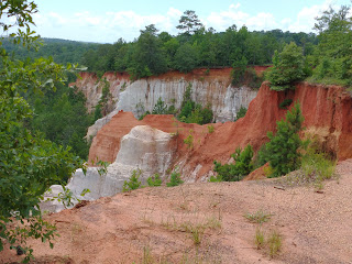
Saturday, July 17, 2021

Georgia's "Little Grand Canyon"


Yesterday's visit was to Providence State Park in Lumpkin, GA which lies on the southwestern border with Alabama. We were surprised to learn that much of the canyon formed due to poor farming practices by early settlers.  Soft soil began washing away in the early 1800s when trees were cleared to  plant crops. By 1850, ditches 3-5 feet deep had been cut into the land. Today, some of them are as deep as 150 feet, and there are 16 canyons over 1,108 acres.


The day was very warm, and very humid, so we took lots of water on our hike. In many places we could see the erosion taking place. We saw trees perched precariously at the edge of the canyon, just waiting for a few more big rains to wash the soil away the holds them on the canyon rim. In one area, we saw a number of rusty old 1950s cars being swallowed up by the forest around them. Due to the environmental damage that removing the vehicles would cause, park officials have decided to leave them alone.

Erosion in the park is ongoing. We could see that the fence that once marked the edge of the trail was now on the edge of the canyon in spots. To keep the trail intact, the park has put down heavy mats and gravel in erosion heavy steeper spots.

More photos here:  https://photos.app.goo.gl/28xCcTKMMAx2QzEq8


Thursday, July 15, 2021

Squeaky sand!

Our route south

Yesterday, we decided to check out some of the lovely towns along the east side of Mobile Bay south of Mobile. The towns of Daphne and Fairhope stood out. Both are distinguished by expansive brick homes with lush landscaping. We were surprised by the hilly topography of this area. The hills were so significant that a bicyclist would have a serious workout traveling the roads. Elsewhere not far from the coast, the landscape is typical southern flat. 

We took a short tour of one of the Daphne neighborhoods. Many of the gorgeous brick homes were built into and around slopes--not what you'd expect along Mobile Bay. As in central Florida, huge, old live oaks and crape myrtles rule the landscape here. Many homeowners have posted home names out on the road, like: "Wright on the Bay", "Sweet Home Alabama", "Bay Daze", and "Happy Ours".

Fairhope live oak tree
We stopped in a town called Fairhope. The previous evening, we saw a story on the local news about a 200+ year-old live oak tree on a bluff over the bay that had been infested with termites. The town had cordoned the tree off, and was considering the question of whether to cut the tree down (!), or spend $10,000 to treat the problem and save it. As we drove through Fairhope, we decided to go find the tree and take a look. It's hard to believe that anyone would consider cutting it down. This tree is fantastic. We learned later that the town decided to treat the tree and save it.

From there, we drove south to the peninsula that
forms the southern end of Mobile Bay and separates it from the Gulf. It's really a sliver of land that felt the brunt of Hurricane Sally that came ashore here with 110 mph winds in September of 2020. It dumped over 20 inches of rain on this area as well. We saw lots of reconstruction here, and some buildings still showing damage from the storm. Many structures have already been resided or reroofed or both. We walked the beach at Fort Morgan, and experienced something we never had before: squeaky sand! The sand made squeaking noises as we walked on it!  We really laughed about this. 

The white sand actually does squeak when you walk on on this stretch of the Gulf of Mexico coast. From the internet: "That’s because the sand from Panama City Beach to Destin to Alabama’s Gulf Shores consists of tiny quartz particles. That fine, sugar-like sand on the Alabama coast has the right shape and make-up to squeak beneath your feet. When we walk over the sand, the particles rub over each other. The air between the grains of sand has to escape. The noise emits from the escaping air and the particles rubbing together." 

On the way back north, we stopped in Fairhope again, and walked out to the end of the 1/4 mile long Fairhope pier and enjoyed the late afternoon. This was a lovely relaxing day.


Monday, July 12, 2021

Southeast tour begins

 Last year, we were disappointed that our trip to Montana and Glacier National Park had to be canceled because Covid concerns had prompted the Blackfeet Nation to close access to their lands. The east side of Glacier National Park falls within the Blackfeet reservation, and so all access to that was cut off as well. We immediately started planning for 2021, and made reservations for a 2 week stay at a campground just outside the park gates. We happily anticipated this trip all year. But the release from Covid restrictions over the past year had people recognizing that RVing is a great way to travel. There was a surge in RV purchases in 2020 of 4-5% over 2019. Anticipated sales for 2021 is 19.5 to 20% over 2020. And all those RVs are cramming themselves into campgrounds, and flooding National Park trails. 

We've been reading the news stories about traffic jams in parks, and conga lines of hikers on trails. This was certainly not the experience we were seeking. We love to be out on a trail in the mountains in the quiet and surrounded by the spectacular beauty of wildflower covered mountainsides and snow capped peaks all around. But not this.

Crowds at Glacier

So, with this in mind, last month we cancelled all our reservations and made different plans. On Sunday we headed north to Alabama and Georgia for a 2+ week swing through what promises to be some beautiful country. Last night we stayed at a nice RV campground in Perry, FL. Tomorrow, we head for Mobile, AL, what has become a favorite place over the last few years.
View at the back of the campground

Our site


Tuesday, April 27, 2021

Little River and Cucumber Gap trail

We started the day with a great breakfast at Hillbilly's restaurant in Wear's Valley. Great meals (I had


Bananas foster French toast), and giant cups of coffee. As soon as you open the door to the restaurant and step inside, you're faced with an old Chevy truck. Great atmosphere here, great food, and friendly staff. One thing we have noticed is that Covid precautions seem to be non-existent here. No one wears masks inside, as far as we can tell. But Covid has definitely hit this area hard. Gatlinburg, Sevierville, and Pigeon Forge and surrounding communities rely on the success of their service businesses for tourists, especially restaurants. It seems that every restaurant is seating at 50% capacity, not for protection's sake, but because they can't get people to work in the restaurants--servers, bus people, etc. We assume that unemployment benefits are more of a draw than the paychecks. Every restaurant we've gone to has notices to exactly that effect, and is posting big "WE'RE HIRING" signs, and we've been told of the problem by restaurant people.

Our first stop today was a loop trail reputed to have great wildflower stands. The first 2 miles followed along the edge of the Little River, a small river that sounded really loud as we hiked along. There were, in fact, nice displays of wildflowers along the edges of the trail. But after our experience at the Sink yesterday, most anything else was bound to pale in comparison. Today was warmer, but started with a nice breeze that made for a pleasant walk. Not long after the trail turned away from the river, we
started in to a 3.7 mile ankle-buster hike, with rocks and roots spread across the path. Soon we came to a place on the trail where we had to cross a fast-running creek. After assessing our limited options for crossing it, we chose to crawl on hands and knees across a makeshift bridge of fallen logs. After that, there were a couple of other creek crossings, but that was the most interesting. Great hike.

We had read that a smaller trail in another part of the park had great wildflowers as well. We headed there, and took that one.

Again, memories of the Sink colored our appreciation for the natural displays of flowers there. But it WAS pretty. 

Photos here: https://photos.app.goo.gl/psNnEsX2DtsQasZx7


Fairyland in the Smokies

Some of the acreage of wildflowers at the bottom of the sink

We are in Townsend, TN, near Smoky Mountain National Park. The Smokies are reknowned for the beauty of their spring wildflower displays, and that was the biggest impetus for us to make this trip. So today we set out for a trail I had discovered while searching the web for "best wildflower trails in the Smokies". I was surprised that even the national park site didn't list this trail, just the trail off which it runs. But descriptions I read said that Whiteoak Sink had a gorgeous display of wildflowers that was not to be missed. So after breakfast, we set out, and arrived at the main trailhead a short while later. The day was cool and comfortable; we started the hike wearing jackets. All along the sides of the trail, we saw many banks of wildflowers: trillium, phlox, wild geranium, white violets, crested iris, and much more.

The trail was flanked by tall hardwoods just coming into leaf. About 1 1/4 miles up the trail, we knew


we had to turn for the Sink trail, but we saw no signs. We continued on until Ray had the idea that we might have passed the turn off. We checked the trail map I had downloaded, and sure enough, we had missed the turn off which had been unmarked. We retraced our steps and started down into the Sink. The trail got narrower and rockier, and we started to note even more wildflowers. 

When we reached the bottom of the Sink, at about 2.1 miles in, we saw why reviews of this trail included words like "magical", "amazing", "spectacular", "surreal", and "outstanding". Laid out before us were acres of wildflowers, a sea of purple, white and pink with dots of yellow. It was as if we were transported to a fairytale place. Mind blown. Unfortunately, the park service had to put up net fencing in certain areas to keep people from trampling the flowers, and stationed 3 park rangers in this area to monitor and guide people around the area. From the bottom, we hiked up to a gravesite of a former resident of the area, Abraham Law, who died in 1844. On the way out, we stopped at a small waterfall, and had a snack. We retraced our path back to the parking lot, even more aware of all the natural beauty we might have missed on the way in.

Photos of the day are here: https://photos.app.goo.gl/DTdrkQrVEaFrqjvD9

Sunday, April 25, 2021

Pearl's, rain, and pastels


One unique feature of our hotel was it's embrace of digital technology. We checked in, chose our room, unlocked our door, and checked out on the Hilton app on my phone. Very cool!

After a nice breakfast, we headed east to a little town called Bishopville (SC) where Pearl's Topiary Garden is the main attraction. Pearl Fryar just wanted to win the Yard of the Month prize awarded by a local garden club. After he took a short Topiary lesson at a local nursery, he set out (about 1988) to transform his property into a living sculpture garden that ultimately became a tourist destination, and an international sensation.

His garden now contains over 400 individual plants that are complemented by his " junk" art  sculptures placed throughout the garden.

We were the only visitors this morning that was on the cool side, and cloudy. The solitude made the visit more interesting and very intimate. The birds were twittering and singing away.

A small restroom building was tucked into the side of the property and emblazoned with a plaque that noted that it was built with the support of the county and the Coca Cola Company.

As we were leaving Pearl's home, we noticed that a few houses down the street seemed to have lots of topiary as well. We drove further up the street to see that that was the case. I imagine that Pearl Fryar shared his skills with his neighbors.

It started to rain heavily shortly after leaving Bishopville, and continued for most of today's drive to Townsend, TN, just outside Smoky Mountain National Park. By the time we reached North Carolina, we were watching
dogwoods, pawlonia, redbud, and magnolias all in bloom, and set in the pastels of newly leafing hardwoods of all shades of green. As we neared the Smokies, clouds hung low over the hills. At one point, Google announced a slowdown ahead and recommended an


alternate route. So, we left the Interstate, and followed along a gorgeous narrow,  winding, 2 lane road bordered by wildflowers and assorted rundown homes. By the time we crossed into Tennessee, it stopped raining, and the sun peeked out for the first time today.

Photos are here: https://photos.app.goo.gl/kCNdXr9Tmv1gNQLY9

Friday, April 23, 2021

A little spring jaunt

Butterweed along the trail

It was a mostly uneventful ride on Interstates from home to Santee, SC, our first stop on this trip. When we first stepped out of the car at a rest area in GA, the air was much cooler than it was when we left home. On with our sweatshirts! Our trip up I95 was a matter of dancing among the throngs of the huge trucks that move America's stuff. There seemed to be 2 trucks for every car on the road.

It's been a while since we've stayed in hotels as we traveled since Rving is our preferred method of travel. But since our RV is having some repair work done, this was our only option. Covid is definitely still making it's mark on hotels. The place we stayed last night supposedly offered breakfast. Their website showed a breakfast room with a toaster, waffle machine, cereal and lots more. The actual reality was a lot different. When we came down in the morning, we found 1 1/4" diameter chocolate chip muffins wrappped in plastic, a bowl of apples, and yogurt along with a carafe of regular coffee, no decaf (which I should be drinking due to high blood pressure). After having the coffee, we headed out and stopped to get a breakfast sandwich. We picked up a sub to split at lunch on the trail.

Today we headed for Congaree National Park which is about 17 miles southeast of Columbia, SC. The ride  to the park was through beautiful farm land and small towns. 

What makes Congaree special? Its forest has one of the highest canopies in the world. Average tree height here is 130 feet, and there are 25 national champion trees (biggest and tallest of their species).


To walk here is like walking in an outdoor cathedral. A highlight is a 2+ mile boardwalk that is raised 6 feet above the forest floor. Even with the elevation, the boardwalk does flood at certain times of the year. Because of it's remote location, Congaree is one of the lesser known and visited National Parks. That makes it the perfect quiet retreat! This was a wonderful time to visit because the mosquito

population (which is normally huge) was at a minimum because it has been dry here. Outside the Visitor Center is a meter that displays the current mosquito situation rated on a 1 to 6 scale. It was a 1+ today, but even so, we slathered on the repellent just to be extra cautious. Sometime in mid-afternoon, we stopped at the side of the trail and had our sub sandwich lunch while sitting on a giant fallen log. The weather was cool, dry, and perfect, the trail lined with clouds of yellow butterweed, dog hobble, flowering holly, and twisted vines and roots. What an awesome, peaceful afternoon!

This evening, we will stay in Columbia and head to the Smokies tomorrow.

More photos here: https://photos.app.goo.gl/EhEV6K2aqt7vViY7A