Thoughts Become Things

Wednesday, July 9, 2025

Denver Botanic Gardens, July 4, 2025


Our last stop on this trip was Denver Botanic Gardens. There is a large conservatory there featuring tropical plants, and it seems that most of the gardens are informal (which I love). It was an enjoyable visit.

photos here: https://photos.app.goo.gl/QDND8iyjcz6vrJRn6


Glen Eyrie, July 2-3, 2025


Glen Eyrie began as the estate of William Jackson Palmer, a railroad magnate and founder of the city of Colorado Springs. He built it about 4 miles north of the city, bordering Garden of the Gods. In 1867, he purchased 10,000 acres at $1.25 per acre to establish the colony later known as Colorado Springs. He later bought an additional 2,225 acres on which he built the estate. In 1909, he died as the result of a fall from his horse at the age of 72. At that time, the estate was valued at $3,000,000. His wife had passed, and his daughters were not in a position to take care of the estate. The girls offered the estate to the city of Colorado Springs at the time, but they refused because of the expense to maintain it. It was sold in 1916 to home developers. But it was the time of WWI, and sales were lacking. The property was purchased in 1938 as a summer home and cattle ranch. In 1950, it was again placed on the market for $500,000 and purchased in 1953 by The Navigators, a non-denominational Christian group that is the current owner. They use this as a retreat and conference center and international offices. To enter the grounds, you have to have a reservation for lodging.

Because of their mission to bring people closer to God, The Navigators have not placed TVs in rooms here, and they do not serve alcohol in the restaurants. The place is meticulously maintained, and the setting is gorgeous, being adjacent to Garden of the Gods. Hammocks and benches have been placed around the estate as places of quiet reflection. There are trails on the estate that were used by Palmer himself, and pathways to walk and enjoy the surroundings. In addition to the main castle (17 rooms), there are 6 other lodges, including the one where we stayed.

On the 3rd, we headed down to the castle for breakfast. It is served buffet style with lots of choices. My favorite was French toast with berry compote and walnuts. Soooooooooo good. When we arrived for breakfast, the patio was full, so we started inside in the dining room. After a bit, as people left, we were able to sit outside on the patio and enjoy the wonderful setting.

Since we could stay on the property until 5 pm, we decided to take one of the trails here. We discovered that he trails were not particularly well maintained, and the maps were sketchy at best. As a matter of fact, we agreed that the trail map was one of the worst we'd ever seen. There were some nice views from the trail, though.

After the hike, we descended to Glen Eyrie grounds, where we lazed in a hammock for maybe close to an hour before moving on.

Photos here: https://photos.app.goo.gl/MPjAEdEB6GPUqHvR6


Shelf Road to Glen Eyrie, July 2, 2025


It was Ray's thought to take the "scenic" road from the place we were staying in Canon City up to Cripple Creek. From there, we were heading to Glen Eyrie in Colorado Springs.

Red Canyon Rd starts out pleasantly enough as a paved route that winds past ranches. Then it turns into Shelf Road, the old Stagecoach trail from Canon City to Cripple Creek back in the mining days. You half expect Indians to come charging over the hill, or stagecoach robbers to be around the next bend. The road is very narrow, and the road has a significant drop off on one side and step uphill on the other. This image (not mine) captures the flavor of it: https://maps.app.goo.gl/MfVr1ymzBmvhGec88. I don't imagine that Hertz thought that their 2025 Nissan Altima was going to be driving on Shelf Road.

The fastest you can go in a normal car is about 10-12 mph. The rocks and ruts and the narrowness of the road are the gating factors, along with rocks sticking out into the road. BUT- OMG what a ride. The scenery is ____ (fill in the blank with a superlative). After driving on the road for maybe a half hour (we weren't really watching the time), and dealing with the lumps and bumps, we came to a sign:

Rough road ahead/ 4WD or High clearance vehicle recommended/ limited maintenance

No kidding. This might have been helpful a few miles back. Not that we would have turned back...

But this drive was definitely a highlight of our trip.

From Cripple Creek, site of a large casino, we headed to Glen Eyrie, our accommodations for tonight, and a new place to explore.

Photos here: https://photos.app.goo.gl/iFHABw54aJNpR6vo6

Royal Gorge Railroad and Bishop Castle, July 1, 2025

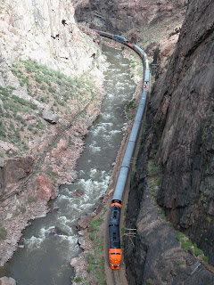
The bridge above the canyon
We had early reservations on the Royal Gorge train that runs along the Arkansas river through a canyon whose sheer rock walls plunge into the river. A highlight of the gorge route is the 1879 hanging bridge that is  suspended on one side under A-frame girders that span the river and are anchored to the rock walls. At one point, the train stops under the Royal Gorge Bridge 955 feet above the river, and the highest bridge in the United States. In addition to the spectacular scenery, we saw many rafters float by on the river.

In the afternoon, we opted to drive down to Bishop Castle, about an hour from Canon City where we were staying. It is located in a pretty remote area. Jim Bishop bought the land in 1959 when he was 15, and started building a home there in 1969. A neighbor had mentioned that the rocks he had surrounded the cottage there looked like a castle, and that comment sparked Jim's imagination. The castle grew from there. He placed the rocks, made the iron stairways for 55 years until he died at the end of 2024 from cancer.


For most of the time he was building he had disputes with the federal government over the rocks he used to build the castle. He took them from the National Forest surrounding his property, and he felt that they were his for the taking. The feds wanted to charge him by the truckload. The government disputed his use of unsanctioned road signs that pointed to his site. Ultimately, official road signs were placed. 

We had been here with Alex in 1992, and we were amazed at how much more had been done on the castle in the interim. It's tallest tower is 160 feet, and he built the whole thing with mothing but his hands. It's an amazing work of art and human patience and industry.

Photos are here: Royal Gorge--https://photos.app.goo.gl/zyYr87g9DCWg7gp67

                            Bishop Castle--https://photos.app.goo.gl/vL31dAQY9m9bJ1ZW8


Tuesday, July 8, 2025

Million Dollar Road, Rte 550, June 30, 2025


We spent the day meandering down the Million Dollar Highway in Colorado. The name came from a comment made at a planning meeting in 1921. At this time, a meeting was held to discuss plans to rebuild the highway. As the men reviewed the contracts to rebuild the highway, one gentleman remarked that all the contracts added up to a figure very close to $1,000,000. In further comments, he began to refer to the road as “…this million-dollar highway….” and the name stuck. 

The Million Dollar Highway stretches for about 25 miles  in western in Colorado and follows the route of U.S. 550 between Silverton and Ouray, Colorado. Although the entire stretch has been called the Million Dollar Highway, it is actually just the twelve miles south of Ouray  to the summit of Red Mountain Pass. This stretch through the gorge is interesting to drive; it is characterized by steep cliffs, narrow lanes, and a lack of guardrails; the ascent of Red Mountain Pass is marked with a number of hairpin curves used to gain elevation, narrow lanes for traffic—many cut directly into the sides of mountains. It's a fantastic road to drive, with mountain views around every turn. Loved, loved, loved it.

In one stretch there is a site with memorials to people who died on the road, by avalanche and road maintenance. 

Photos here: https://photos.app.goo.gl/ZPRBTZKmDs19ytNt8


Through Ouray to Mesa Verde, June 28-29, 2025

Within a few minutes of setting out on our day's travels, I got something in my eye--it started as just an irritation, then grew to be painful, to the point where I couldn't keep my left eye open. Fortunately, we were near Montrose, a relatively large town of 21,000, and we stopped there for a visit to Urgent Care. The doctor there couldn't see anything in the eye, but recommended a saline wash that I could buy at Walmart down the road. We did pick it up there, I used the wash, and it got better--gradually.

Onward.

Ouray

We spent the next 2 days driving through spectacular mountain scenery through Ouray and Telluride to Cortez, and then visiting Mesa Verde. The mountains were wonderful, Mesa Verde, a mystery.

It's a mystery to me how the people of Mesa Verde lived their daily lives climbing up and down the cliff walls. 

It was hot (again 90s temps), and we only took short walks to the sights. I was interested to learn the Mesa Verde is not a true mesa, but a cuesta, a ridge with a steep cliff on one side, and a gentle slope on the other. We had done all the cliff tours many years ago, and just enjoyed our walks here. We ate our lunches by the edge


of the mesa in the shade. 

All around the various towns of Colorado, we have been amused at the names of Marijuana "Dispensaries" aka stores: The Weedery, Delirious, CanaCare, Pure Cannabliss, Rocky Mountain High, The Buzz...

Photos here: https://photos.app.goo.gl/UJNXshj2ekLnE5pz9

Colorado National Monument, June 27, 2025


After Grand Mesa, we drove north to Colorado National Monument. Temperatures were reaching near 100, and we wisely decided not to hike, but to just drive the road, Rim Rock Drive. Along its 23 miles, it's easy to take in  redrock canyons, crisp blue skies, and glorious views.

We spent the rest of the day traveling and stopping at viewpoints along the way. The photos are at https://photos.app.goo.gl/JsNwqc65cnVQuTgNA

Grand Mesa, June 27, 2025

The motel we're staying at offers eggs prepared any way you like as well as multiple other choices. Nice surprise. It's not a fancy hotel, but a smaller motel. Very clean and comfortable. I must have done good hotel research because all so far have been superior quality.

We were told that the haze we kept seeing at Gunnison and also here at Grand Mesa was from California wildfires. It is very noticeable here. Grand Mesa is only 23 miles from Grand Mesa, reportedly the largest flat-topped mountain in the world, at 500 square miles, 40 miles long, 11,000 feet in elevation and 6,000 feet higher than the surrounding valleys. It contains over 300 lakes. Rounded river cobbles beneath Grand Mesa's cap confirms that it was originally a valley, like Black Canyon of the Gunnison rim. 

We started our time at Grand Mesa by stopping at the Visitor Center to get information on what to do and where to go. There, we met a ranger from, of all places, East Rochester, NY! He directed us to the road to access a particular trailhead, and also told us of a back road that would be worthwhile to drive because of the beautiful meadows there. 

The place where the attack happened

We found the trailhead he had recommended, and started up the very rocky, very steep trail that had not been maintained--we had to push through brush and trees. Finally, we reached a wider trail that passes by a lake. The trail was around 2 lakes-a loop. We started down the path and were inundated by a swarm, not just a few, but a swarm, or mosquitos. Ray's white shirt had lots of little black flecks all over it. The little buggers were swarming around my head, and all I could hear was that familiar whine in my ears. NO WAY. We agreed that 3 hours of bug swatting was not in our future, so we turned around and came back up the trail to our car. We figured that the lakes were probably a perfect breeding ground for the mosquitos, and hadn't encountered them before on our travels in the west.

At this point, we decided to try the back road suggested by the ranger. It was awesome with wildflower meadows on both sides of the road. The driving was slow, because the road was rough and rocky. But it was not so rocky as to prevent a tractor trailer from motoring up the road in the opposite direction. I think it had a long cattle trailer attached. We continued on to Land's End Observatory, an old ranger observatory on the edge of the Grand Mesa. There are excellent views of the surrounding area there. Rather than returning the way we came, we continue on the dirt road, which offered some hair-raising twists and turns as we descended the mesa, but was really quite entertaining! 

Photos here: https://photos.app.goo.gl/r6qUFTWSerb3Btu8A

Black Canyon North Rim, June 26, 2025


The North Rim of Black Canyon offers better views of the narrowest part of the canyon, and the access is down a gravel road. Because of this, it is relatively less visited and so, quieter. 

Here we took a trail that brought us to breathtaking views of the steep canyon walls. We saw one area of the rim that had rounded rocks, like you would see at a beach. We learned that the rocks are rounded as tetament to the fact that the river was once at the top of the canyon. These rocks were washed smooth by the Gunnison River itself about 2 million years ago. We were standing 1100 feet above the river. Very cool.

All along the edge of the canyon were Utah juniper trees. These trees can tolerate drought, intense heat or cold, and strong winds. If conditions become poor enough, the tree will isolate a limb, cutting off nutrients to it. That kills part of the tree allowing the rest of it to survive. By doing this, the tree is able to


redistribute nutrients to more critical parts of the tree, and lessen the overall demand to sustain life. That's amazing! We saw some really big and gnarled junipers here.

After the trail, we sat in the quiet shade of a pinyon pine and ate lunch. We then drove the north rim road and took the rim trails.

Dinner was at a local golf club in Cedaredge. We sat outside and ate in the company of about 24 raucous golfers ending their tournament day. It was fun listening to their banter as we watched the deer munch of the landscaping around the building. Wonderful end to the day!

Pictures here: https://photos.app.goo.gl/ginkgLi19BPX3NV86

Black Canyon South Rim, June 25, 2025

 As we set out for today's destination, a black bear popped out of the woods just ahead of us! When he saw us advancing, he popped back into the trees. The day was hot (90s) because we were not at higher elevation, only 5300 feet.

Today took us to the south rim of the Black Canyon of the Gunnison, a favorite place for us. For me, it brings the memories of the first time we ever visited there 50 years ago when I was 24 (yikes!). We were tent camping there and it was the first time I ever saw the Milky Way. I was awestruck.

Soth rim of the canyon is chock full of gorgeous views of the canyon and river, a green ribbon surrounded by what looks like painted vertical walls.

We took just about all the trails available (mostly short), and then headed down to the East Portal at the river. You get a distinctly different view of the canyon from the bottom looking up. We love the peacefulness of the setting, because few people venture there.

Photos here: https://photos.app.goo.gl/qPc9Hxzjdih5iLFc8

Crested Butte, June 24, 2025

It was cloudy and cool when we set out this morning, with temps in the 50s. We had breakfast at the hotel and spoke with some bikers, including 2 really nice guys from the Asheville, NC area.

Man! it's dry, dry, dry here. My sinuses and skin are dealing with it.

The town of Crested Butte is very touristy, with tons of what I call "shoppees" (not shops, but shoppes.) We decided to hike a loop trail that is reputed to be loaded with wildflowers. It did not disappoint. OMG!!


Fields of purple and yellow, dotted with white, blue, and red, with the mountains as the backdrop made this hike take much longer than it might otherwise. We both had to stop frequently to take pictures, or just enjoy the spectacular views. A couple of hours into the hike, a thunderstorm rolled through. The rain only lasted for 15 minutes or so. But the flowers were amazing. At the end of the trail, we sat and had our apples and granola bars feasting on the views there.

After lunch, we stopped at the Visitor Center, where we learned that there was a cool back road, Route 12, that would take us up to Gothic and another beautiful wildflower area. This road was such a treat. Coupled with the fact that almost no one else was on it, the views were peaceful beauty. We also had been advised that we could return to Gunnison, where we were staying, via another dirt road cutoff from Route 12, Route 730. Unfortunately, we missed the turn off and kept driving. About 8 miles past the point where we should have turned, we had to stop. There was a large flock of sheep scattered all over: in the meadows on

Large rocks in the road ahead

our sides and on the road ahead. The bleating of the sheep was deafening! It was a very cool interlude in our day, though. We turned around at that point and ultimately did find our cutoff to return to Gunnison. That road was interesting as well--branches jutting into the road, basketball-size rocks in the road, ruts...

Photos of that day:  https://photos.app.goo.gl/46CMzjR1498qGA8T6

Family then mountains, June 23, 2025

 We spent the first few days of our Colorado trip visiting with Larry and Rose at their home in Centennial, just outside Denver. On 7/23, we headed out to Gunnison, where we would stay for a couple of nights. The drive there is always cool, going over Monarch Pass, 11,312 feet. We both had memories of going over the pass in the RV and towing the Elantra, a slow uphill grind. This time, in our rented car, we zipped past what looked like evidence of a large wildfire in the past. Dead trees were everywhere. Further inquiry showed that the dead trees were actually caused by spruce beetle infestation. 90% of the mature spruce trees in the area have been wiped out by these beetles. 90%!! The large number of dead trees creates a significant fuel load, increasing the risk of catastrophic wildfires, so a project is underway to remove the dead trees.

We stayed in Gunnison that night and had dinner in a restaurant there that was adorned with 20 to 30 large stuffed elk, deer, moose, and bison heads. We stopped at Walmart to pick up some snack stuff for the trip that would serve as lunch: apples, pretzels, granola bars, and also a $5 foam cooler to keep water and the apples cool. This was, by far, the smallest Walmart we have visited. The average size of a Walmart Supercenter is 182,000 square feet. This one was 43,000 square feet.

No photos today.